Filter: Categories of Wisconsin Historical Images
Filter: Subject of Land use, Urban
Filter: Subject of transportation
Filter: Categories of Wisconsin Historical Images
Filter: Subject of Land use, Urban
Filter: Subject of transportation

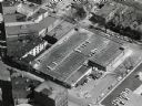
| Date: | 11 1928 |
|---|---|
| Description: | Aerial view of Stoughton, including the central business district, residential areas, the Yahara River, and the surrounding countryside. |

| Date: | 11 1928 |
|---|---|
| Description: | Aerial view residential areas of Windsor and the surrounding countryside. |

| Date: | 11 1928 |
|---|---|
| Description: | Aerial view of Black Earth residential area and the surrounding countryside. |

| Date: | 11 1928 |
|---|---|
| Description: | Aerial view of Cross Plains, including residences and the surrounding countryside. |
| Date: | 1955 |
|---|---|
| Description: | West Doty Street, from Monona Avenue looking toward South Carroll Street, showing the back side of Madison Newspapers, Inc. The building was added on to in... |
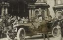
| Date: | 09 01 1912 |
|---|---|
| Description: | Theodore Roosevelt in front of the Deutscher Club. The club later became the Wisconsin Club. |

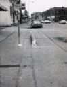
| Date: | 02 08 1970 |
|---|---|
| Description: | Chicago, Milwaukee, St. Paul & Pacific Railroad tracks running down the middle of East Wilson Street from South Baldwin Street to Dickinson Street. |
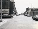
| Date: | 07 28 1970 |
|---|---|
| Description: | Traffic on Stevens Point's Second Street. |
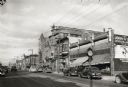
| Date: | 1967 |
|---|---|
| Description: | Traffic on Oxford Street (State Highway 21&73), with a parking meter in the foreground and old storefronts in the distance. |

| Date: | 12 03 1980 |
|---|---|
| Description: | Giese residence located on State Highway 80/82 in Union Center taken by the State Department of Transportation to illustrate the pond ditch drainage on the... |
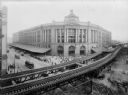
| Date: | 1900 |
|---|---|
| Description: | Elevated view of the South Station terminal with elevated track in the foreground, Boston, Massachusetts. Streetcars and pedestrians can be seen on the str... |

| Date: | 1868 |
|---|---|
| Description: | Elevated view of the intersection of Main and Carroll Streets, showing the home of Nathaniel Dean (where the Inn on the Park Hotel is now located), and St.... |

| Date: | 07 01 1836 |
|---|---|
| Description: | Original plat map of the town of Madison on the four lakes. |
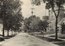
| Date: | 1905 |
|---|---|
| Description: | Langdon Street and the lower campus of the University of Wisconsin, including the Armory (Red Gym or Old Red). |
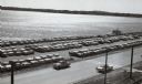
| Date: | 1957 |
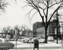
|---|---|
| Description: | Law Park along Lake Monona, after filling in the shoreline to construct a road and parking lot. This is the current site of the Monona Terrace. |
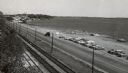
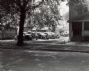
| Date: | 10 03 1958 |
|---|---|
| Description: | Law Park parking lot along Lake Monona. |
| Date: | 10 03 1958 |
|---|---|
| Description: | The Law Park parking lot, on the shore of Lake Monona. |
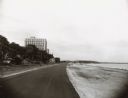
| Date: | 1940 |
|---|---|
| Description: | 1100 block of South Sixteenth Street with storefronts and automobile traffic. Cable car tracks run down the middle of the street. |
If you didn't find the material you searched for, our Library Reference Staff can help.
Call our reference desk at 608-264-6535 or email us at: