 Filter: Categories of Wisconsin Historical Images
Filter: Subject of Landforms
Filter: Type of Map or Atlas
Filter: Categories of Wisconsin Historical Images
Filter: Subject of Landforms
Filter: Type of Map or Atlas

| Date: | 1910 |
|---|---|
| Description: | Wisconsin Geological and Natural History Survey, by Lawrence Martin reproduced from a model of the state prepared by W.O. Hotchkiss and F.T. Thwaites and m... |

| Date: | 1868 |
|---|---|
| Description: | Showing the counties, towns and railroads. Partly colored. Scale: 1 inch = 20 miles. |

| Date: | 1916 |
|---|---|
| Description: | Southeastern Wisconsin which lies east of Whitewater and south of Port Washington. |

| Date: | |
|---|---|
| Description: | Plan of township no. 3 north, range no. 5 west of the 4th principal meridian. |

| Date: | 1862 |
|---|---|
| Description: | Lithography of C. Van Benthuysen. |

| Date: | 1839 |
|---|---|
| Description: | Shows locations of cities, towns, villages, post hamlets, canals, rail and stage roads. Includes table of steamboat routes and distances; vignette of "Maid... |

| Date: | 1857 |
|---|---|
| Description: | A color-coded map of the Lake Superior region, including portions of Wisconsin, Minnesota and Michigan. |
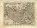
| Date: | 1576 |
|---|---|
| Description: | Map of America. This is the oldest map in the Parker collection. It is based on the geography of Ortelius, who is considered to be the creator of the first... |

| Date: | 1698 |
|---|---|
| Description: | Copperplate engraving. Scale [ca. 1:11,500,00]. |

| Date: | 1755 |
|---|---|
| Description: | Hand-colored. Paris: 1755. Scale [ca. 1:3,000,000]. |

| Date: | 1930 |
|---|---|
| Description: | Pictorial map of Glacier National Park, Montana and Waterton Lakes National Park, Alberta. Illustrated by Joe Scheurle, it depicts white people, American ... |

| Date: | |
|---|---|
| Description: | A hand-drawn map of Indian boundary lines in southwest Virginia. It also includes the Duck River and the Elk River. |

| Date: | 1906 |
|---|---|
| Description: | Topographical map of Turville Point and lands to the South to Nine Springs Creek. |

| Date: | 1950 |
|---|---|
| Description: | This map of east central Wisconsin around Lake Winnebago and the southern portion of Green Bay shows the moraines, drumlins, eskers, sand dunes, old beach ... |

| Date: | 1905 |
|---|---|
| Description: | A reproduction of the Wisconsin portion of Louis Hennepin's 1698 map showing the location of the Ho-Chunk Tribe, the Hurons, the Illinois as well as other ... |

| Date: | 1839 |
|---|---|
| Description: | A chart showing the geological cross-section and the height above the surrounding landscape of several locations, such as Platte Mound in Wisconsin, and th... |

| Date: | 1905 |
|---|---|
| Description: | A geological survey map of southeastern Wisconsin, showing Pleistocene-era deposits, including drifts, moraines, drumlins and deposits from various glacier... |

| Date: | 1852 |
|---|---|
| Description: | A hand-colored map showing portions of present-day Iron and Vilas counties north of the Manitowish River as part of the Upper Peninsula of Michigan. The Wi... |

| Date: | 1852 |
|---|---|
| Description: | Map shows Wisconsin counties by color and includes rivers, lakes and some cities. This information is also given for eastern Minnesota and northern Illinoi... |
If you didn't find the material you searched for, our Library Reference Staff can help.
Call our reference desk at 608-264-6535 or email us at:
