Filter: Categories of Wisconsin Historical Images
Filter: Subject of Landforms
Filter: Creator Name of Unknown
Filter: Categories of Wisconsin Historical Images
Filter: Subject of Landforms
Filter: Creator Name of Unknown
| Date: | |
|---|---|
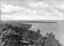
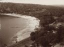
| Description: | Elevated view of Shanty Bay at Peninsula State Park, established in 1910. |
| Date: | |
|---|---|
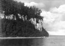
| Description: | View of Eagle Cliff at Peninsula State Park, established in 1910. |
| Date: | |
|---|---|
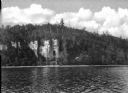
| Description: | View across water towards Eagle Cliff at Peninsula State Park, established in 1910. |
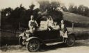
| Date: | 06 09 1929 |
|---|---|
| Description: | The Nofsinger family poses with their automobile, a Model T Ford. |

| Date: | |
|---|---|
| Description: | A hand-drawn map of Indian boundary lines in southwest Virginia. It also includes the Duck River and the Elk River. |
| Date: | |
|---|---|
| Description: | Elevated view of the north end of Devil's Lake and Cliff House. A number of buildings are around the shoreline with railroad tracks in the foreground. A lo... |

| Date: | |
|---|---|
| Description: | Elevated view of Devil's Lake from the top of the bluffs, talus slope visible on right. |

| Date: | |
|---|---|
| Description: | Lewis Arms and friends perch on a bluff overlooking Devil's Lake. From left to right are: Arms, Eddie Elvord (Alvord?), Mary Rogers, and George Green (Gree... |

| Date: | |
|---|---|
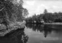
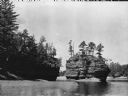
| Description: | View of a rock formation called The Ink Stand located on the Wisconsin River. |
| Date: | |
|---|---|
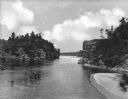
| Description: | Elevated view of the Jaws river segment on the Wisconsin River. The Jaws area is comprised of the space between High Rock and Romance Cliff. |
| Date: | |
|---|---|
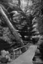
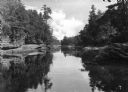
| Description: | View of the Narrows, a channel of the Wisconsin River that is 52 feet wide and 100 feet deep. The first bridge spanning the river was built across the Narr... |
| Date: | |
|---|---|
| Description: | Elevated view of the Jaws river segment on the Wisconsin River. The Jaws area is comprised of the space between High Rock and Romance Cliff. |
| Date: | |
|---|---|
| Description: | View of the Sugar Bowl rock formation on the Wisconsin River. The photograph caption reads "Camera Works by Sweet MPLS." |
| Date: | |
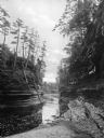
|---|---|
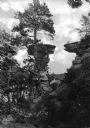
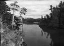
| Description: | View of the channel behind Steamboat Rock in the Wisconsin River. |
If you didn't find the material you searched for, our Library Reference Staff can help.
Call our reference desk at 608-264-6535 or email us at: