 Filter: Categories of Wisconsin Historical Images
Filter: Subject of Landforms
Filter: Creator Name of Unknown
Filter: Categories of Wisconsin Historical Images
Filter: Subject of Landforms
Filter: Creator Name of Unknown

| Date: | 1900 |
|---|---|
| Description: | A Hydrographic map of Lake Mendota that shows the depths of the lake through contour lines and cross sections of the lake. Also shown in the map are the ad... |

| Date: | 1932 |
|---|---|
| Description: | View from shoreline of three men in a canoe on Lake Menomin near a point of land. |

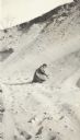
| Date: | 1933 |
|---|---|
| Description: | A single pine tree grows on the ledge of a bluff along Highway 80 near Hub City. A road sign warns of a curve. The road is rutted and there is patchy snow ... |
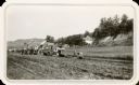
| Date: | 1931 |
|---|---|
| Description: | Men using horse-drawn and gasoline powered road equipment work on Highway 80 near Rockbridge. A wooded bluff rises steeply behind a farmhouse. Barns, a sil... |

| Date: | |
|---|---|
| Description: | A stereoscopic view from the shore of Maiden Rock in Lake Pepin. |
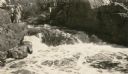
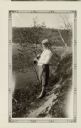
| Date: | 1931 |
|---|---|
| Description: | A group of people stand on a ledge overlooking Copper Falls. |
| Date: | |
|---|---|
| Description: | A woman, Grace, digs in the sand as she kneels in a sand pit near the intersection of Fish Hatchery Road and Park Street. A note on the back of the photogr... |
| Date: | |
|---|---|
| Description: | Florance Trask poses standing in a sand pit located near the intersection of Fish Hatchery Road and Park Street. Another woman, Grace, can be seen digging ... |

| Date: | |
|---|---|
| Description: | A woman, Grace, smiles as she poses while standing in a sand pit near the intersection of Fish Hatchery Road and Park Street. A note on the back of the pho... |
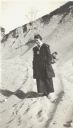
| Date: | 1935 |
|---|---|
| Description: | Selma Eidsmoe, wearing knickers and a head scarf, poses holding a gun over her shoulder. She is standing on a bluff above the Pecatonica River valley. She ... |
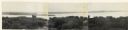
| Date: | 1930 |
|---|---|
| Description: | Panoramic elevated view to the northwest from the Capitol Square. |

| Date: | 1861 |
|---|---|
| Description: | The township of Primrose, which is a detail from the plat map of Dane County. |

| Date: | 1861 |
|---|---|
| Description: | The township of Montrose, which is a detail from a Dane County plat map. |

| Date: | 1895 |
|---|---|
| Description: | Elevated view from bluffs, looking north-east toward Lake City, Minnesota and Lake Pepin of the Mississippi River. |

| Date: | |
|---|---|
| Description: | Exterior of the menu for Paul's Cafe, with a bird's-eye view map of "Washburn's Natural Deep Water Land Locked Harbor," Chequamegon Bay, and the Apostle Is... |
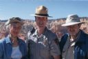
| Date: | 05 2005 |
|---|---|
| Description: | Joan Obey, Ranger Brent McGinn and Congressman David Obey at Bryce Canyon National Park. Canyon walls are in the far background. |

| Date: | |
|---|---|
| Description: | Letterhead of Johnson & Melaas, merchant tailors and cloth dealers, "Buyers of wool and Wisconsin leaf tobacco," with an engraving of a waterfront view of ... |
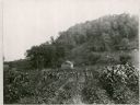
| Date: | |
|---|---|
| Description: | View of a log cabin at the foot of a hill, with a field in the foreground. |
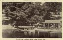
| Date: | 1910 |
|---|---|
| Description: | View across water towards the North Side Landing. There is a covered tour boat at the edge of the lake and passengers on board. At the shoreline is a cabin... |

| Date: | 1910 |
|---|---|
| Description: | View from shoreline of boats, including an excursion boat, on the shoreline and along both sides of a pier. There are three men on the pier at Kirkland Lan... |
If you didn't find the material you searched for, our Library Reference Staff can help.
Call our reference desk at 608-264-6535 or email us at: