 Filter: Categories of Wisconsin Historical Images
Filter: Subject of Landforms
Filter: Creator Name of Unknown
Filter: Year of 1800-1899
Filter: Categories of Wisconsin Historical Images
Filter: Subject of Landforms
Filter: Creator Name of Unknown
Filter: Year of 1800-1899
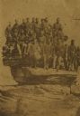
| Date: | 04 20 1864 |
|---|---|
| Description: | Company D, Twenty-first Wisconsin Volunteer Infantry. Top row (left to right): John Buboltz, Spencer Orlup, J. Henry Otto, Lyman C. Wait, Andrew Jackson, W... |
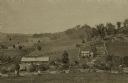
| Date: | 1875 |
|---|---|
| Description: | View from a distance of a farm in a valley owned by Alex(ander?) Smith. There is a wooden fence in the foreground surrounding the farm. |

| Date: | 1872 |
|---|---|
| Description: | The sidewheel packet, Red Wing, in the Mississippi River near Queen's Bluff below Trempealeau, Wisconsin. |

| Date: | 1874 |
|---|---|
| Description: | Bird's-eye map of Chippewa Falls. |

| Date: | 1860 |
|---|---|
| Description: | Bird's-eye drawing of New Glarus. |

| Date: | 02 26 1887 |
|---|---|
| Description: | Bird's-eye map of Ashland, and the Apostle Islands in Lake Superior. Caption reads: "Ashland and the Apostle Islands." |
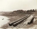
| Date: | 05 05 1897 |
|---|---|
| Description: | Elevated view of Wisconsin Central freight cars in a rural storage yard near Manitowoc. |

| Date: | 1875 |
|---|---|
| Description: | Aerial view of Alma along Mississippi River, with bluffs along the horizon. |

| Date: | 1870 |
|---|---|
| Description: | Elevated view of the town, looking northwest. The Chippewa River is in the foreground, with a lot of buildings, an intersection, and distant hills. One bui... |

| Date: | 1856 |
|---|---|
| Description: | Isthmus of Madison, including Lake Mendota, or Great Lake, and Lake Menona [sic]. |

| Date: | 07 01 1836 |
|---|---|
| Description: | Original plat map of the town of Madison on the four lakes. |

| Date: | 1864 |
|---|---|
| Description: | Fort Crawford was decommissioned in 1856, having outlived its usefulness as a frontier post. During the Civil War, however, it functioned as a military ho... |
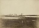
| Date: | 1863 |
|---|---|
| Description: | View from shoreline of the side-wheel steamship "Thomas Powell," probably in southern waters. Industrial buildings are in the background. |
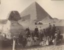
| Date: | 1896 |
|---|---|
| Description: | A group portrait of Violet Lee Dousman (back row, 3rd from left) and her fellow travelers, guides and Egyptians on a trip to Giza, Egypt. Five people are r... |

| Date: | 1861 |
|---|---|
| Description: | The township of Primrose, which is a detail from the plat map of Dane County. |

| Date: | 1861 |
|---|---|
| Description: | The township of Montrose, which is a detail from a Dane County plat map. |

| Date: | 1895 |
|---|---|
| Description: | Elevated view from bluffs, looking north-east toward Lake City, Minnesota and Lake Pepin of the Mississippi River. |

| Date: | 09 01 1856 |
|---|---|
| Description: | This map is pen-and-ink and shows farm lots, other lots of land sectioned by acres, bluffs, and a coulee. Also included are notations in pencil and blue in... |

| Date: | 1899 |
|---|---|
| Description: | A plat map showing Lake Monona, the isthmus in Madison, and the towns of Burke and Blooming Grove. |

| Date: | 1871 |
|---|---|
| Description: | A map of California showing railroad lines and reservations. |
If you didn't find the material you searched for, our Library Reference Staff can help.
Call our reference desk at 608-264-6535 or email us at: