Filter: Categories of Wisconsin Historical Images
Filter: Subject of Landscape
Filter: Type of Drawing
Filter: Categories of Wisconsin Historical Images
Filter: Subject of Landscape
Filter: Type of Drawing
| Date: | 07 16 1849 |
|---|---|
| Description: | South Pass in Wyoming; sketched by Wilkins on his 151-day journey from Missouri to California on the Overland Trail (also known as the Oregon Trail). Wilki... |
| Date: | 07 17 1849 |
|---|---|
| Description: | Pacific Springs, Wyoming; sketched by Wilkins on his 151-day journey from Missouri to California on the Overland Trail (also known as the Oregon Trail). Wi... |
| Date: | 07 23 1849 |
|---|---|
| Description: | Bluff near Green River, where Wilkins' wagon train crossed by ferry; sketched by Wilkins on his 151-day journey from Missouri to California on the Overland... |
| Date: | 07 24 1849 |
|---|---|
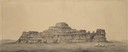
| Description: | Cathedral Rock in Wyoming with three wagons; sketched by Wilkins on his 151-day journey from Missouri to California on the Overland Trail (also known as th... |
| Date: | 08 03 1849 |
|---|---|
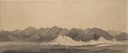
| Description: | Bear or Soda Springs along Bear River in Idaho; sketched by Wilkins on his 151-day journey from Missouri to California on the Overland Trail (also known as... |
| Date: | 1866 |
|---|---|
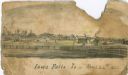
| Description: | An image from a sketchbook of the town of Iowa Falls. There is a fence in the foreground and buildings in the background. |

| Date: | |
|---|---|
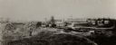
| Description: | Exterior of Fort Donelson with landscape including sparse buildings and trees. |

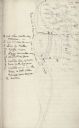
| Date: | |
|---|---|
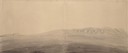
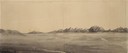
| Description: | A preliminary sketch of a landscape with partially drawn cannons in the foreground and tents in the background. |
| Date: | 07 1947 |
|---|---|
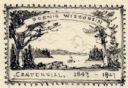
| Description: | One of two pencil sketches submitted by Leon Pescheret of Whitewater, Wisconsin, to the Wisconsin Centennial Committee to be considered for the Wisconsin C... |
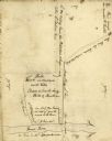
| Date: | |
|---|---|
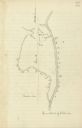
| Description: | Drawn map of the Catawba River, fishing creek, and surrounding landscape from the Sumter Papers. |
| Date: | |
|---|---|
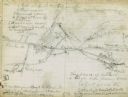
| Description: | Drawn map of the Hanging Rock Battlefield in the Thomas Sumter Papers. |
| Date: | |
|---|---|
| Description: | Drawn map of Hanging Rock Battlefield from the Thomas Sumter Papers. |
| Date: | |
|---|---|
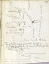
| Description: | Drawn map of Blackstock's Plantation battlefield from the Sumter Papers. |
| Date: | |
|---|---|
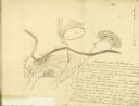
| Description: | Drawn map of the Fish Damn Ford battlefield from the Thomas Sumter Papers. |
| Date: | |
|---|---|
| Description: | Drawn map of Blackstock's Plantation battlefield from the Thomas Sumter Papers. |
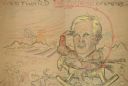
| Date: | 1924 |
|---|---|
| Description: | A hand-drawn cartoon in crayon entitled "Westward The Course Of Empire". It features Frederick Jackson Turner on a rocking horse with a sunset in the backg... |
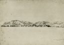
| Date: | 08 1852 |
|---|---|
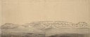
| Description: | Pencil drawing of Rattlesnake Bluff and the town of Arena from a distance across a plain. A row of buildings runs along the foot of the gently rolling hill... |
If you didn't find the material you searched for, our Library Reference Staff can help.
Call our reference desk at 608-264-6535 or email us at: