Filter: Categories of Wisconsin Historical Images
Filter: Subject of Landscape
Filter: Year of 1900-1999
Filter: County of Dane
Filter: Categories of Wisconsin Historical Images
Filter: Subject of Landscape
Filter: Year of 1900-1999
Filter: County of Dane
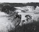
| Date: | 1963 |
|---|---|
| Description: | Sand and gravel pit used by the Dane County highway department as a source of supply. |

| Date: | 1920 |
|---|---|
| Description: | Unidentified small girl holding a parasol, posed beside railroad tracks. |

| Date: | 1960 |
|---|---|
| Description: | View of landscape at the top of Rocky Glen Road, looking over flooded fields at sunrise. |

| Date: | 1964 |
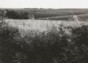
|---|---|
| Description: | Scattered young trees, seedlings and saplings, in a field. |

| Date: | 1905 |
|---|---|
| Description: | View of Madison in the far distance taken from the third floor of a home at 216 Campbell Street, in University Heights. There is a power line suspended in ... |

| Date: | 1920 |
|---|---|
| Description: | This map shows a plat of the area, numbered blocks and lots, local streets, roads, parks, Nakoma Country Club golf course, and landscaping. The map is orie... |

| Date: | 1928 |
|---|---|
| Description: | View from grassy hill of uptown Cross Plains. The Catholic Church (St. Francis Xavier) is on the right, and farmhouses and other buildings are among fields... |

| Date: | 1928 |
|---|---|
| Description: | View down valley towards the back of the Lutheran Church and cemetery. Houses and barns are in the valley below, and more hills are in the far background. ... |

| Date: | 1918 |
|---|---|
| Description: | This is a collection of two maps. One map is blue line print that includes illustrations and shows the location of buildings, gardens, plant life, and spri... |

| Date: | 05 24 1961 |
|---|---|
| Description: | View of small domed hill on Highway 19, surrounded by fields. |

| Date: | 1910 |
|---|---|
| Description: | Watercolor design for a conservation poster made by a Wisconsin high school student as part of a competition. The poster has an image of trees in silhouett... |
| Date: | 1906 |
|---|---|
| Description: | Watercolor painting of the Yahara River at Lake Monona. |

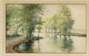
| Date: | 1906 |
|---|---|
| Description: | Watercolor painting of the Yahara River at Lake Monona, with trees in the background and wetlands in the foreground. |
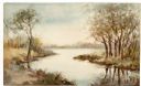
| Date: | 1906 |
|---|---|
| Description: | Watercolor painting of the Yahara River, with large trees on the shoreline. Note: '05 & '06 were the years when Tenney Park and the Yahara River Parkway ... |

| Date: | 1919 |
|---|---|
| Description: | Aerial view looking north over Lake Monona towards the Wisconsin State Capitol on the isthmus. Lake Mendota is in the background. |

| Date: | 1979 |
|---|---|
| Description: | A specimen of Quercus alba, judged to be the largest of its species in Wisconsin, standing alone in a pasture on a sunny summer day. |
If you didn't find the material you searched for, our Library Reference Staff can help.
Call our reference desk at 608-264-6535 or email us at: