Filter: Categories of Wisconsin Historical Images
Filter: Subject of Landscape
Filter: Year of 1900-1999
Filter: Reproduction Rights of For Sale
Filter: Categories of Wisconsin Historical Images
Filter: Subject of Landscape
Filter: Year of 1900-1999
Filter: Reproduction Rights of For Sale

| Date: | 11 19 1970 |
|---|---|
| Description: | Exterior view of the uniquely designed house of Byron Bloomfield at 1010 Edgehill Drive in Shorewood Hills, which is built into the side of a sharp slope. ... |

| Date: | 1909 |
|---|---|
| Description: | View from Sunset Point in Owen Park, which is now a part of Hoyt Park. Lake Mendota is in the distance. |

| Date: | 1953 |
|---|---|
| Description: | Aerial view of La Crosse and the Mississippi River. In the foreground is the new bridge as of 1953. |

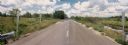
| Date: | 06 29 1968 |
|---|---|
| Description: | View of rural Monroe County Highway P, looking east toward a house in the curve of the road. |
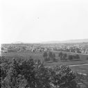
| Date: | 1912 |
|---|---|
| Description: | Elevated view of Wausau from the edge of town looking toward residences and businesses. Hills are in the far background. |
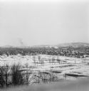
| Date: | 1912 |
|---|---|
| Description: | Winter view over fields of town with hills in the far background. |
| Date: | 07 20 1988 |
|---|---|
| Description: | Panoramic view from the Big Sandy Creek Bridge, looking north on Marathon County Highway Q. |

| Date: | 03 16 1984 |
|---|---|
| Description: | A wintertime panoramic view of the bridge on Rainbow Drive, a local road in the Town of Halsey, Marathon County, looking east. |
| Date: | 10 30 1987 |
|---|---|
| Description: | Panoramic view of 28th Avenue winding through the Town of Maine in Marathon County. |

| Date: | 03 03 1988 |
|---|---|
| Description: | View from bridge over Wild Creek on Marathon County Highway M. The creek appears frozen, although in flood. Several farms can be seen in the distance. |

| Date: | 04 07 1988 |
|---|---|
| Description: | Panoramic view over Juneau County Highway Q, about four miles south of the entrance to Buckhorn State Park. |

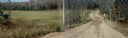
| Date: | 10 26 1986 |
|---|---|
| Description: | Green Elm Road Bridge over the east fork of Hemlock Creek, showing the rocks used to prevent erosion. |

| Date: | 11 05 1986 |
|---|---|
| Description: | Green Lake County Highway M meandering toward a red barn in the distance on a November day, an archtypal Wisconsin landscape. |
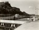
| Date: | 1935 |
|---|---|
| Description: | Locks on the Mississippi River, a nine foot channel. A man is standing above the locks. Bluffs are in the background. |

| Date: | 09 1982 |
|---|---|
| Description: | Nollenberg Road Bridge in the Town of Union. |

| Date: | 03 1963 |
|---|---|
| Description: | Panoramic landscape view of the Fey Farm near Dexterville, Wood County. The view incudes the farmstead and much of the surrounding acreage and woodlands. T... |

| Date: | 1968 |
|---|---|
| Description: | Elevated view of Ansel Adams making a photograph from the platform mounted atop his International Travelall. He is using an 8 x 10 field camera and an assi... |

| Date: | 1968 |
|---|---|
| Description: | Ansel Adams atop a camera platform on his International Travelall inserts an 8 x 10 film holder into his camera. |
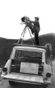
| Date: | 1968 |
|---|---|
| Description: | Ansel Adams inserts the film holder into his 8 x 10 camera. He is photographing from a platform mounted on the top of his International Travelall truck. |
If you didn't find the material you searched for, our Library Reference Staff can help.
Call our reference desk at 608-264-6535 or email us at: