 Filter: Categories of Wisconsin Historical Images
Filter: Subject of Landscape
Filter: Year of 1900-1999
Filter: Year of 1980-1989
Filter: Subject of transportation
Filter: Categories of Wisconsin Historical Images
Filter: Subject of Landscape
Filter: Year of 1900-1999
Filter: Year of 1980-1989
Filter: Subject of transportation
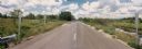
| Date: | 07 20 1988 |
|---|---|
| Description: | Panoramic view from the Big Sandy Creek Bridge, looking north on Marathon County Highway Q. |
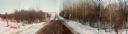
| Date: | 03 16 1984 |
|---|---|
| Description: | A wintertime panoramic view of the bridge on Rainbow Drive, a local road in the Town of Halsey, Marathon County, looking east. |
| Date: | 10 30 1987 |
|---|---|
| Description: | Panoramic view of 28th Avenue winding through the Town of Maine in Marathon County. |
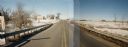
| Date: | 03 03 1988 |
|---|---|
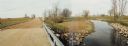
| Description: | View from bridge over Wild Creek on Marathon County Highway M. The creek appears frozen, although in flood. Several farms can be seen in the distance. |

| Date: | 04 07 1988 |
|---|---|
| Description: | Panoramic view over Juneau County Highway Q, about four miles south of the entrance to Buckhorn State Park. |
| Date: | 10 26 1986 |
|---|---|
| Description: | Green Elm Road Bridge over the east fork of Hemlock Creek, showing the rocks used to prevent erosion. |

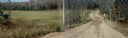
| Date: | 11 05 1986 |
|---|---|
| Description: | Green Lake County Highway M meandering toward a red barn in the distance on a November day, an archtypal Wisconsin landscape. |

| Date: | 09 1982 |
|---|---|
| Description: | Nollenberg Road Bridge in the Town of Union. |

| Date: | 01 1983 |
|---|---|
| Description: | "This photo shows the John Steger home on the West Bend Road, foreground, the Willard Bogenschneider farm in the middle distance, and Theresa Station and t... |

| Date: | 08 1980 |
|---|---|
| Description: | Two men holding a banner that reads: "Re-think I-43" in protest of the newly built highway. The highway runs from Green Bay to Beloit by way of Milwaukee. |
| Date: | 1982 |
|---|---|
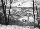
| Description: | Bare trees frame an elevated view of Gays Mills taken from a snowy hilltop, showing Highway 131, lower right, as it curves into Main Street. Highway 171 en... |
| Date: | 1984 |
|---|---|
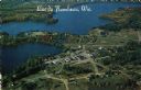
| Description: | Aerial postcard of Lac du Flambeau village and surrounding lakes. Caption reads: "Lac du Flambeau, Wis." Text on reverse reads: "On State Hwy 47 between Po... |
If you didn't find the material you searched for, our Library Reference Staff can help.
Call our reference desk at 608-264-6535 or email us at: