Filter: Categories of Wisconsin Historical Images
Filter: Subject of Landscape
Filter: Year of 1900-1999
Filter: Categories of Wisconsin Historical Images
Filter: Subject of Landscape
Filter: Year of 1900-1999
| Date: | 1935 |
|---|---|
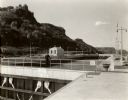
| Description: | Locks on the Mississippi River, a nine foot channel. A man is standing above the locks. Bluffs are in the background. |

| Date: | 09 1982 |
|---|---|
| Description: | Nollenberg Road Bridge in the Town of Union. |

| Date: | 03 1963 |
|---|---|
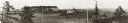
| Description: | Panoramic landscape view of the Fey Farm near Dexterville, Wood County. The view incudes the farmstead and much of the surrounding acreage and woodlands. T... |

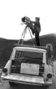
| Date: | 1968 |
|---|---|
| Description: | Elevated view of Ansel Adams making a photograph from the platform mounted atop his International Travelall. He is using an 8 x 10 field camera and an assi... |
| Date: | 1968 |
|---|---|
| Description: | Ansel Adams atop a camera platform on his International Travelall inserts an 8 x 10 film holder into his camera. |
| Date: | 1968 |
|---|---|
| Description: | Ansel Adams inserts the film holder into his 8 x 10 camera. He is photographing from a platform mounted on the top of his International Travelall truck. |

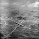
| Date: | 1955 |
|---|---|
| Description: | An aerial view of Mineral Point showing the construction of State Highway 23-39. |
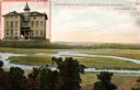
| Date: | 1910 |
|---|---|
| Description: | View of the outdoor landscape as seen from a window in the Stoughton Hospital, along with an inset of the building in the upper left corner. Caption reads:... |

| Date: | 1914 |
|---|---|
| Description: | Entrance gate at Taliesin, and the landscape around the gate. Taliesin was the summer residence of architect Frank Lloyd Wright. Taliesin is located in the... |
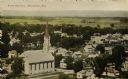
| Date: | 1907 |
|---|---|
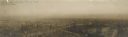
| Description: | Elevated view of church and town. Caption reads: "Bird's-Eye View, Mazomanie, Wis." |
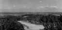
| Date: | 1950 |
|---|---|
| Description: | A view from Rib Mountain looking southeast toward Rothschild and the Wisconsin River. The sign on the road in the foreground reads: "Dangerous Road, Drive ... |
| Date: | 1954 |
|---|---|
| Description: | Aerial view of the Phoenix Proving Ground during the 1954 Industrial Power Roundup, a large event promoting International Harvester's construction equipmen... |
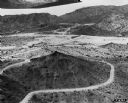
| Date: | 1966 |
|---|---|
| Description: | Aerial view of International Harvester's Phoenix Proving Ground. Opened in 1947, the proving ground was used by International Harvester through the 1970's ... |

| Date: | 11 1951 |
|---|---|
| Description: | Aerial view of US Highway 14 southeast of La Crosse descending into Mormon Coulee. The original caption of the print, which is undated, describes the road ... |

| Date: | 1979 |
|---|---|
| Description: | Aerial view of Interstate I-90/94 at Camp Douglas, looking northwest. |
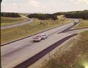
| Date: | 1965 |
|---|---|
| Description: | At many places in Wisconsin, the Interstate Highway is divided by a wide median strip that provides a scenic view for the motorist. This photograph shows ... |

| Date: | 1924 |
|---|---|
| Description: | Front and back covers of Scenic Wisconsin Motorways, a guide to Wisconsin roads compiled by Victor F. Pettric and published by the Wisconsin Motorists Asso... |
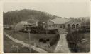
| Date: | 1910 |
|---|---|
| Description: | Elevated view of Home store, Prairie Farm. Includes additional buildings. Caption reads: "Home Store Prairie Farm Wis." |
If you didn't find the material you searched for, our Library Reference Staff can help.
Call our reference desk at 608-264-6535 or email us at: