 Filter: Categories of Wisconsin Historical Images
Filter: Subject of Lumber
Filter: Subject of indian reservations
Filter: Categories of Wisconsin Historical Images
Filter: Subject of Lumber
Filter: Subject of indian reservations
| Date: | |
|---|---|
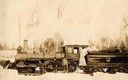
| Description: | Three men stand in the snow in front of the Wisconsin & Northern Railroad engine #2 (the second locomotive with this number) in the woods on the Menominee ... |

| Date: | 1872 |
|---|---|
| Description: | This map, which includes eastern Iowa, northern Illinois and a portion of Michigan's Upper peninsula, shows the township survey grid and identifies countie... |

| Date: | 1896 |
|---|---|
| Description: | A map of Iron County, Wisconsin, shows vacant Wisconsin Central Rail Road lands, settlers houses, land sold by Wisconsin Central R.R., schools, churches, s... |

| Date: | 1898 |
|---|---|
| Description: | A map of Iron County, Wisconsin, shows vacant Wisconsin Central Rail Road lands, settlers houses, land sold by Wisconsin Central R.R., schools, churches, s... |

| Date: | |
|---|---|
| Description: | Map of northern Iron County, Wisconsin, shows town sections and railroads in the towns of Saxon, Kimball, and Gurney. It also includes the area of the La P... |
If you didn't find the material you searched for, our Library Reference Staff can help.
Call our reference desk at 608-264-6535 or email us at: