 Filter: Categories of Wisconsin Historical Images
Filter: Subject of Lumber trade
Filter: Year of 1900-1999
Filter: Categories of Wisconsin Historical Images
Filter: Subject of Lumber trade
Filter: Year of 1900-1999

| Date: | 1925 |
|---|---|
| Description: | View from bridge or boat railing of piles of lumber in the Paine Lumber Company yards on the banks of the Fox River. There is a boat house on the left shor... |
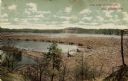
| Date: | 1910 |
|---|---|
| Description: | A colored photographic postcard view of a large log jam in the Dells Pond at Eau Claire. There are "booms" and several men standing on logs. Caption reads:... |
| Date: | 1900 |
|---|---|
| Description: | Colorized postcard view across field toward the lumber mill. Caption reads: "Dan'l Shaw Lumber Company Mill, Eau Claire, Wis." |
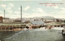
| Date: | 1910 |
|---|---|
| Description: | Colorized postcard view across river towards the North Western Lumber Company's mills. Caption reads: "North Western Lumber Co's. Mills, Eau Claire, Wis." |

| Date: | 06 1923 |
|---|---|
| Description: | Sanborn map of Ashland, which includes Chequamegon Bay. |
| Date: | 04 12 1931 |
|---|---|
| Description: | Ernst Schmidt has captioned this photograph, "The C. M. & St. P. train arriving at Zenda at 10:30 A. M. on Sunday, April 12. Alma, Edward and Conrad came u... |

| Date: | 1982 |
|---|---|
| Description: | This standard U.S.G.S. topographic map was annotated by civil engineer and railroad historian James P. Kaysen to show the location of existing and defunct ... |

| Date: | 1912 |
|---|---|
| Description: | Marinette plat map, Township 37 N., Range 19 E. |

| Date: | 1912 |
|---|---|
| Description: | Marinette County, Township 37 N., Range 20 E. |

| Date: | 1912 |
|---|---|
| Description: | Marinette County, Fract. Township 36 N., Ranges 21 and 22 E. |

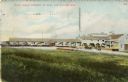
| Date: | 1920 |
|---|---|
| Description: | Elevated view of lumber yard. Houses are on a hill in the far background. |

| Date: | 1920 |
|---|---|
| Description: | Elevated view of lumberyard at factory. There is a road in the foreground with what appear to be streetcar tracks. |

| Date: | 12 1912 |
|---|---|
| Description: | Sanborn Map of Sun Prairie. The map highlights the public and parochial schools, the exhange, and church buildings, etc. |

| Date: | 1908 |
|---|---|
| Description: | Elevated view of Glidden. The lumber mill is in the foreground. A church and a water tower are on the horizon. |
| Date: | 06 18 1925 |
|---|---|
| Description: | A E.S. Adkins & Co. delivery truck with a trailer at a lumber yard. |

| Date: | 1972 |
|---|---|
| Description: | A topographic map of the Blackwell quadrangle. |

| Date: | 03 26 1926 |
|---|---|
| Description: | View of a man sitting in the driver's seat of a truck parked near a building at a lumberyard. There are houses in a neighborhood in the background. |

| Date: | 03 06 1926 |
|---|---|
| Description: | Left side view of a man sitting in the driver's seat of a delivery truck near a building with lumber stacked in front of it. There are houses in a neighbor... |

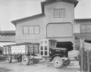
| Date: | 05 27 1926 |
|---|---|
| Description: | View across parking area towards lumber delivery trucks parked in front of a large, wooden sided building, with clerestory windows. A sign on the side of t... |

| Date: | 05 27 1926 |
|---|---|
| Description: | View across road towards two lumber delivery trucks parked in front of the Howard Lumber Co. |
If you didn't find the material you searched for, our Library Reference Staff can help.
Call our reference desk at 608-264-6535 or email us at: