| Date: | 1739 |
|---|---|
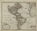
| Description: | This map shows the territorial claims of the western hemisphere by the European powers, as well as the names of major cities, geographical features, and pa... |

| Date: | 1710 |
|---|---|
| Description: | A seminal and fairly accurate map of the Great Lakes Region up to Baffin's Bay in Northern Canada. This is possibly the first printed map to locate Detroit... |

| Date: | 1703 |
|---|---|
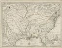
| Description: | Map of the Golf of Mexico and surrounding countries from the Great Lakes down to the northern most parts of South America. L'Isle labels cities, towns, and... |

| Date: | 1724 |
|---|---|
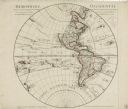
| Description: | Map showing the mountains, rivers, lakes, settlements, islands, and regions of North and South America. Characteristic of de L'Isle, this map is highly det... |

| Date: | 1782 |
|---|---|
| Description: | Map of America covering the Rio Grande to the Atlantic Ocean, showing boundaries, the colonies, cities, settlements, Native American lands and villages, m... |
If you didn't find the material you searched for, our Library Reference Staff can help.
Call our reference desk at 608-264-6535 or email us at: