 Filter: Categories of Wisconsin Historical Images
Filter: Subject of Maps
Filter: Type of Map or Atlas
Filter: Year of 1900-1999
Filter: Year of 1990-1999
Filter: Categories of Wisconsin Historical Images
Filter: Subject of Maps
Filter: Type of Map or Atlas
Filter: Year of 1900-1999
Filter: Year of 1990-1999

| Date: | 1994 |
|---|---|
| Description: | This map shows historical sites, picnic grounds, public boat landings, canoe and motor boat trips, and resort locations. The left margin of the map include... |
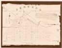
| Date: | 1994 |
|---|---|
| Description: | This cadastral map shows Mill Pond, buildings, some landowners, cemetery, and out-lots. The upper right corner includes a statement about Ceresco. |

| Date: | 1990 |
|---|---|
| Description: | This map includes two insets: Plat of New Holstein village and Village of Chilton. The map also includes a table of statistics showing the assessed value o... |

| Date: | 1990 |
|---|---|
| Description: | This map, in addition to the Fort ground and buildings, shows owners of outbuildings, heights of buildings in stories, fences, roads, gardens, and cemetery... |
If you didn't find the material you searched for, our Library Reference Staff can help.
Call our reference desk at 608-264-6535 or email us at: