 Filter: Categories of Wisconsin Historical Images
Filter: Subject of Maps
Filter: Creator Name of Unknown
Filter: Type of Drawing
Filter: Categories of Wisconsin Historical Images
Filter: Subject of Maps
Filter: Creator Name of Unknown
Filter: Type of Drawing

| Date: | 07 1838 |
|---|---|
| Description: | A map diagram of Indian effigy mounds seven miles east of Blue Mounds in the Wisconsin Territory. |
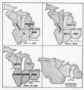
| Date: | 01 11 1805 |
|---|---|
| Description: | Four map illustrations showing the political subdivisions of the Northwest Territory from 1805 through 1834. |

| Date: | 1780 |
|---|---|
| Description: | Hand-drawn plan for the layout of the town of Clarksville, bordering Mayfield Creek and Liberty Creek. Fort Jefferson is shown between the townsite and the... |

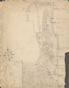
| Date: | 1855 |
|---|---|
| Description: | Fox-Wisconsin portage and canal map, when the canal was not yet built. From a map in the office of the city clerk at Portage. "The old trail, the location ... |
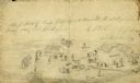
| Date: | |
|---|---|
| Description: | A rough sketch of Camp Judas, the 12th Regiment's first bivouac under Colonel George E. Bryant. |

| Date: | 04 15 1915 |
|---|---|
| Description: | A sketch of Little Lake Butte des Morts and the surrounding area, including Neenah and Menasha. |
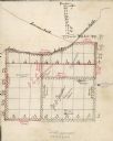
| Date: | |
|---|---|
| Description: | Hand-drawn map detailing acreage of land leased by G.E. Lemmon and J. Walker. |
| Date: | 1929 |
|---|---|
| Description: | An unsigned, hand-drawn map of properties owned by members of the Brumder family on the northwest shore of Pine Lake in 1929. Named Villa Henrietta, the pr... |
If you didn't find the material you searched for, our Library Reference Staff can help.
Call our reference desk at 608-264-6535 or email us at: