 Filter: Categories of Wisconsin Historical Images
Filter: Subject of Maps
Filter: Creator Name of Unknown
Filter: Categories of Wisconsin Historical Images
Filter: Subject of Maps
Filter: Creator Name of Unknown

| Date: | 1924 |
|---|---|
| Description: | Front and back covers of Scenic Wisconsin Motorways, a guide to Wisconsin roads compiled by Victor F. Pettric and published by the Wisconsin Motorists Asso... |

| Date: | 1904 |
|---|---|
| Description: | A map showing the design for a park fronting on Lake Monona Bay. (Now called Brittingham Park) taken from between pages 44 & 45 of the 1905 Madison Park a... |

| Date: | |
|---|---|
| Description: | Map of location of bones, used in bison excavation project. |

| Date: | 1855 |
|---|---|
| Description: | Fox-Wisconsin portage and canal map, when the canal was not yet built. From a map in the office of the city clerk at Portage. "The old trail, the location ... |
| Date: | 1857 |
|---|---|
| Description: | Plat map of Kekoskee, Wisconsin. Kekoskee is a village in Dodge County, in the Beaver Dam metropolitan area. The community name derives from Indian term fo... |
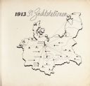
| Date: | 1943 |
|---|---|
| Description: | Map of Concentration Camps in Germany, titled "1943 31 Zuchtstationen," where the SS kept angora rabbits for their wool raising projects at concentration c... |
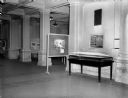
| Date: | |
|---|---|
| Description: | Art exhibit on the first floor of the State Historical Society of Wisconsin Building. |
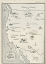
| Date: | 06 1930 |
|---|---|
| Description: | A map of the western states showing "public playlands," mostly national parks. |
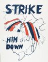
| Date: | 02 1971 |
|---|---|
| Description: | Political propaganda poster featuring a red, white, and blue eagle being struck down from the sky, accompanied by the phrase: "Strike Him Down." The eagle... |
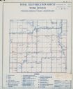
| Date: | |
|---|---|
| Description: | Rural electrification survey map of Marquette county in Westfield township. |
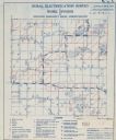
| Date: | |
|---|---|
| Description: | Rural electrification survey map of Waushara county in Springwater township. |
| Date: | |
|---|---|
| Description: | A sign above a large map of Wisconsin counties is in Latin: "Pro Deo Et Patria," meaning For God and Country, and on the left is a decorated cross, on top ... |
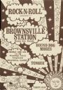
| Date: | 06 1971 |
|---|---|
| Description: | Poster advertising for a Rock-n-Roll music festival, featuring Warner Brothers recording artist Brownsville Station, Hound Dog Moses, and Tongue. Promoted ... |
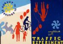
| Date: | 08 1971 |
|---|---|
| Description: | Poster advertising for an event occurring between August 1971 and February 1972 called the "Traffic Experiment," in Madison. Features screen printed silhou... |

| Date: | 1959 |
|---|---|
| Description: | University of Wisconsin-Madison campus. Numbers in circles identify buildings across campus with the building index. Black arrows point out important infor... |
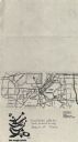
| Date: | 1979 |
|---|---|
| Description: | Map for location of the Magic Picnic, a celebration of the lesbian and gay community, which took place in Brittingham Park. |
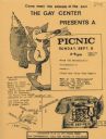
| Date: | 1979 |
|---|---|
| Description: | Poster for picnic presented by the Gay Center at Vilas Park. Includes an image of a fox and telephone. |
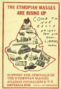
| Date: | 09 1974 |
|---|---|
| Description: | Poster publicizing a rally at Library Mall on the University of Wisconsin-Madison campus. Text reads: "The Ethiopian Masses Are Rising Up. Support the stru... |
If you didn't find the material you searched for, our Library Reference Staff can help.
Call our reference desk at 608-264-6535 or email us at:

