 Filter: Categories of Wisconsin Historical Images
Filter: Subject of Maps
Filter: Subject of human settlements
Filter: Community of Madison
Filter: Categories of Wisconsin Historical Images
Filter: Subject of Maps
Filter: Subject of human settlements
Filter: Community of Madison

| Date: | 1879 |
|---|---|
| Description: | Bird's-eye view of Wisconsin State University, now the University of Wisconsin-Madison. Vignettes include Ladies Hall, South Dormitory, University Hall, As... |
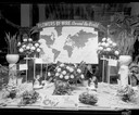
| Date: | 12 05 1952 |
|---|---|
| Description: | Rentschler Floral Company Floral Telegraph Delivery window display, "Flower's-by-Wire, Around the World." |
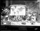
| Date: | 12 08 1952 |
|---|---|
| Description: | Rentschler Floral Company, 230 State Street, Floral Telegraph Delivery window display with plants and floral arrangements, banner with world map and "Flowe... |

| Date: | |
|---|---|
| Description: | Poster advertising the Elmside lots for summer homes by Lake Monona. |
| Date: | 01 1947 |
|---|---|
| Description: | Joseph W. Jackson (Col. Bud), executive director of the Madison and Wisconsin Foundation, standing next to a map of the isthmus. |

| Date: | 1917 |
|---|---|
| Description: | The Lake Forest community plan, a model community that was planned for the site where the University of Wisconsin Arboretum now stands. |

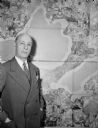
| Date: | 11 10 1944 |
|---|---|
| Description: | Mayor F. Halsey Kraege standing in front of a 1930 City of Madison map. |
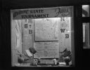
| Date: | 03 17 1947 |
|---|---|
| Description: | Wisconsin Felton Sporting Goods window display of state map and pairings chart for 1947 State Basketball Tournament. "Welcome State Tournament Fans." |

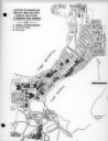
| Date: | 1959 |
|---|---|
| Description: | University of Wisconsin-Madison campus. Numbers in circles identify buildings across campus with the building index. Black arrows point out important infor... |
| Date: | 1979 |
|---|---|
| Description: | Map for location of the Magic Picnic, a celebration of the lesbian and gay community, which took place in Brittingham Park. |
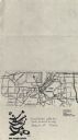
| Date: | 03 16 1950 |
|---|---|
| Description: | Map of areas surveyed by block number as part of the Madison Housing Authority Survey of Substandard Housing. |
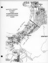
| Date: | 03 16 1950 |
|---|---|
| Description: | Map of locations by block of dwellings rated as blighted as part of the Madison Housing Authority Survey of Substandard Housing. |
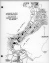
| Date: | 03 16 1950 |
|---|---|
| Description: | Map of locations of blocks of dwellings rated as slums, as part of the Madison Housing Authority Survey of Substandard Housing. |
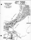
| Date: | 03 16 1950 |
|---|---|
| Description: | Map of locations by blocks or areas of dwelling units in which violations of ordinance were apparent as part of the Madison Housing Authority Survey of Sub... |

| Date: | 03 16 1950 |
|---|---|
| Description: | A chart showing distribution of 1,148 substandard dwelling units found in the survey area, by basic type of fault, as part of the Madison Housing Authority... |

| Date: | 08 27 1956 |
|---|---|
| Description: | Doris Ardelt, secretary of the Madison Civil defense office, hands out comic books to Mary Anthony, left, and Susan Peerenboom for distribution by the Girl... |

| Date: | |
|---|---|
| Description: | Back, front, and inside front cover of the menu from The Restaurant at Baron's department store, with "A Historical Map of Madison" focusing on the isthmus... |

| Date: | 06 08 1960 |
|---|---|
| Description: | Blueprint plat of Sunset Hills sub-division. |

| Date: | 1913 |
|---|---|
| Description: | This photocopy map shows plots with owners' names, land use both commercial and agricultural, and lot outlines on University land. Lake Mendota is labeled ... |
If you didn't find the material you searched for, our Library Reference Staff can help.
Call our reference desk at 608-264-6535 or email us at: