 Filter: Categories of Wisconsin Historical Images
Filter: Subject of Maps
Filter: Subject of human settlements
Filter: Categories of Wisconsin Historical Images
Filter: Subject of Maps
Filter: Subject of human settlements
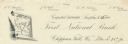
| Date: | |
|---|---|
| Description: | Numbered letterhead of the First National Bank, with a map of Wisconsin and a starred location marker for Chippewa Falls, a medallion, and a flowering stal... |

| Date: | 08 27 1956 |
|---|---|
| Description: | Doris Ardelt, secretary of the Madison Civil defense office, hands out comic books to Mary Anthony, left, and Susan Peerenboom for distribution by the Girl... |

| Date: | 1932 |
|---|---|
| Description: | Map of the Middle East accompanying an article on International's involvement in building the Iraq Pipe Line. Headline text on the page reads: "Internation... |
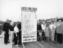
| Date: | 03 1998 |
|---|---|
| Description: | "Village officials help kick off Valley Estates Subdivision." |

| Date: | |
|---|---|
| Description: | Back, front, and inside front cover of the menu from The Restaurant at Baron's department store, with "A Historical Map of Madison" focusing on the isthmus... |

| Date: | 06 08 1960 |
|---|---|
| Description: | Blueprint plat of Sunset Hills sub-division. |
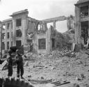
| Date: | 09 18 1944 |
|---|---|
| Description: | Two soldiers in the lower left look at a map. Behind them is what remains of the Brest Post Office. Just under the decorative stone cornice at the top is t... |

| Date: | |
|---|---|
| Description: | Map and advertisement for the Casa del Norte Tea Rooms, with a grid of several blocks in downtown Duluth highlighting the tea rooms as well as other notabl... |
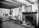
| Date: | 1936 |
|---|---|
| Description: | View of a room in Pendarvis House. There is a map of Cornwall over the fireplace. A bedwarmer and a bellows sit at the base of the hearth. |

| Date: | |
|---|---|
| Description: | Front and back covers of the Mortons Surf Club menu, with a black on blue grid of Chicago streets from Lake Michigan to Vincennes Avenue, and E. 45th to E.... |

| Date: | |
|---|---|
| Description: | Exterior of the menu for Paul's Cafe, with a bird's-eye view map of "Washburn's Natural Deep Water Land Locked Harbor," Chequamegon Bay, and the Apostle Is... |
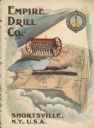
| Date: | 1900 |
|---|---|
| Description: | Catalog cover featuring an illustration of an Empire Drill on a map of the northeast United States. A railroad train is traveling east to west from Albany ... |
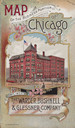
| Date: | 1893 |
|---|---|
| Description: | Front cover of a brochure for Champion Mowers and Binders. Features a color illustration of the office building of the Warder, Bushnell and Glessner Compan... |

| Date: | 1966 |
|---|---|
| Description: | A colored map depiction of Door County, Wisconsin, with pictorial highlights, titled: "Door County — Wisconsin's Air Conditioned Peninsula Playground." |

| Date: | 04 15 1915 |
|---|---|
| Description: | A sketch of Little Lake Butte des Morts and the surrounding area, including Neenah and Menasha. |
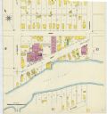
| Date: | 1907 |
|---|---|
| Description: | A Sanborn map of Green Bay, prominently featuring the East River. |

| Date: | 1890 |
|---|---|
| Description: | This map shows the congressional districts lines in accordance with the 1890 census. Districts are labeled by number and color. Original caption reads, "Sh... |

| Date: | 09 1894 |
|---|---|
| Description: | This map shows Congregational churches and Home Missionary churches. County boundaries and county seats are also labeled. The original caption reads, "Cong... |
| Date: | 1895 |
|---|---|
| Description: | This map shows the populations for each county in accordance with the census of 1895. The original captions read, " Total population-1,937,915. Diagram sho... |
If you didn't find the material you searched for, our Library Reference Staff can help.
Call our reference desk at 608-264-6535 or email us at:
