Filter: Categories of Wisconsin Historical Images
Filter: Subject of Maps
Filter: Subject of intellectual life
Filter: Categories of Wisconsin Historical Images
Filter: Subject of Maps
Filter: Subject of intellectual life
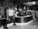
| Date: | 09 21 1928 |
|---|---|
| Description: | Loraine Hotel lobby with local business directory next to registration desk, male customer at registration counter and two clerks in front of Western Union... |
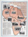
| Date: | 1930 |
|---|---|
| Description: | Advertising poster for International Special Delivery trucks. Features photographic illustrations of a journey across the Sahara desert over a map of Afric... |
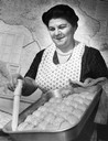
| Date: | 11 15 1963 |
|---|---|
| Description: | Pastry maker removes oil with baster from pan of baked baklava against the backdrop of a map of Armenia. |
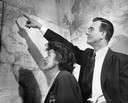
| Date: | 1950 |
|---|---|
| Description: | A man and woman look at wall-size maps as he points to the east coast of the United States. |
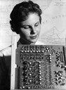
| Date: | 1950 |
|---|---|
| Description: | Jean Hoffman looks over a printed circuit board in the foreground, with a map of Madison, Wisconsin on the wall behind her. |
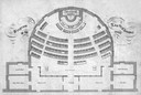
| Date: | 1860 |
|---|---|
| Description: | Floor plan and seating chart for the Assembly for their first meeting in the East Wing of new Wisconsin State Capitol building. After the completion of th... |

| Date: | |
|---|---|
| Description: | Looking West from Knight Block, with shipping piers and sailing ships on right side, railroad on left, trees in background. Horse-drawn carriages on street... |
| Date: | 1909 |
|---|---|
| Description: | Illustration of town. Caption reads: "Bird's-eye View, Lyons, Wisconsin. A Village of natural environments, choice residence locations, desirable factory s... |

| Date: | 1655 |
|---|---|
| Description: | Frontispiece to Newe Welt vnd americanische Historien (1655). |

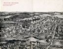
| Date: | 1905 |
|---|---|
| Description: | Bird's-eye view of Manitowoc on the shores of Lake Michigan. A map of the northeastern part of the United States at the top indicates Manitowoc's location ... |
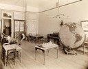
| Date: | 1893 |
|---|---|
| Description: | Male and female students read and practice math at the State School for the Deaf as a teacher looks on from the head of the class. |
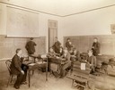
| Date: | 1893 |
|---|---|
| Description: | Interior of the State School for the Blind, perhaps a study or room for recreation. Included in the room are several tables with small models, a piano, and... |

| Date: | 1938 |
|---|---|
| Description: | A colorful pictorial map of Australia, featured on the front and back cover of a special Australian edition of International Trail. |
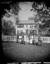
| Date: | 1874 |
|---|---|
| Description: | The Ole Wettlesen family poses in the yard in front of a picket fence with women knitting. Two standing men appear to be examining an unfolded map. The fra... |

| Date: | 08 24 1876 |
|---|---|
| Description: | Hand-drawn plan of the battleground of Huycks. |

| Date: | 03 26 1876 |
|---|---|
| Description: | Hand-drawn map showing the place of Hook's defeat in York County in South Carolina. |

| Date: | 1850 |
|---|---|
| Description: | Lithograph of a map drawn to indicate a mine on land owned by Mineral Point Mining Co. in the lead region of southwestern Wisconsin. |
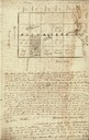
| Date: | 01 12 1844 |
|---|---|
| Description: | Letter from Thomas Steel, Waukesha County physician and farmer, to his father, James Steel, in London, England. It includes a hand-drawn map of Milwaukee C... |

| Date: | 05 05 1947 |
|---|---|
| Description: | Blaney Farms bookkeeper at a desk in the office. |
If you didn't find the material you searched for, our Library Reference Staff can help.
Call our reference desk at 608-264-6535 or email us at: