Filter: Categories of Wisconsin Historical Images
Filter: Subject of Marshes
Filter: Year of 1900-1999
Filter: Categories of Wisconsin Historical Images
Filter: Subject of Marshes
Filter: Year of 1900-1999
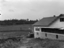
| Date: | 09 1934 |
|---|---|
| Description: | View of a cranberry marsh and warehouse. In the foreground is a warehouse for the storage of harvested cranberries. |

| Date: | 1905 |
|---|---|
| Description: | View of town behind a prairie field and a lake. Caption reads: "Packwaukee, Wis." |

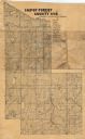
| Date: | 1972 |
|---|---|
| Description: | This map on 5 sheets features a title page sheet with business directory and shows section numbers, roads, railroads, saw mills, churches, blacksmith shops... |

| Date: | 1916 |
|---|---|
| Description: | This Wisconsin Conservation Commission map from 1916 shows Peninsula State Park in the Town of Gibraltar, Door County, Wisconsin. Depicted are open and pla... |

| Date: | 1916 |
|---|---|
| Description: | This version of a 1916 Wisconsin Conservation Commission map shows Peninsula State Park in the Town of Gibraltar, Door County, Wisconsin. Depicted are open... |

| Date: | 1914 |
|---|---|
| Description: | This early 20th century map shows the township and range system, sections, railroads, roads, lakes, wetlands, and streams in the western Sawyer County town... |

| Date: | 1974 |
|---|---|
| Description: | This 1968 map identifies resorts in the Lac du Flambeau Indian Reservation region of Wisconsin, covering parts of Iron, Vilas, Oneida, and Price counties. ... |

| Date: | 1968 |
|---|---|
| Description: | This map is ink and color on printed grid. Shows geology, portage trails, timber type, some landownership, hydrology, and marshes in part of Florence Count... |
| Date: | 1908 |
|---|---|
| Description: | Map shows swamps, windfalls, roads and railroads. Status of some land marked (O, S, X) but lacks explanation. |

| Date: | 1975 |
|---|---|
| Description: | This map shows settlers, Indian trails, roads, marshes, and forests as they appeared in 1800-1840. "A bicentennial map of Racine County for the benefit of ... |
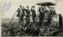
| Date: | 09 08 1914 |
|---|---|
| Description: | Five men in hats and jackets, some holding the levers on a gang plow pulled by a Rumley tractor, pose for a group portrait. One man in work clothes stands ... |

| Date: | 1914 |
|---|---|
| Description: | View of a drainage ditch in Horicon Marsh. A man is on a path along the left of the ditch. |
| Date: | 1914 |
|---|---|
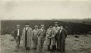
| Description: | Group of well-dressed men standing in front of a plowed segment of Horicon Marsh. |

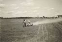
| Date: | 10 1914 |
|---|---|
| Description: | View of furrowed ground in Horicon Marsh and men on a tractor in the process of plowing a drained portion of the marsh. |

| Date: | 1910 |
|---|---|
| Description: | Shows existing and proposed parks, railroads, and marshes in a color coded key. "Contour interval 20 feet." Lake Wingra, Lake Mendota, and Lake Monona are ... |

| Date: | 1908 |
|---|---|
| Description: | Title at top: "G.F. Sanborn Company Timber and Farming Lands." Map shows acreages, roads, railroads, and swamps in parts of Vilas and Oneida counties. |
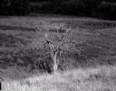
| Date: | 07 12 1964 |
|---|---|
| Description: | Dead tree at the edge of a marsh. The background fades to black. |
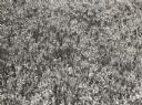
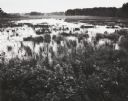
| Date: | 06 1939 |
|---|---|
| Description: | Cranberry plants in bloom at Cranmoor marsh. |
| Date: | 1938 |
|---|---|
| Description: | Dusting a cranberry marsh to combat blunt-nosed leaf-hoppers, Cranberry Lake Development Co. |
If you didn't find the material you searched for, our Library Reference Staff can help.
Call our reference desk at 608-264-6535 or email us at: