 Filter: Categories of Wisconsin Historical Images
Filter: Subject of Marshes
Filter: Year of 1900-1999
Filter: Year of 1900-1909
Filter: Categories of Wisconsin Historical Images
Filter: Subject of Marshes
Filter: Year of 1900-1999
Filter: Year of 1900-1909

| Date: | 1904 |
|---|---|
| Description: | Monona Bay from the railroad trestle looking southwest, close to where the railroad tracks cross North Shore Drive, (now Brittingham Park), with old houses... |
| Date: | 1900 |
|---|---|
| Description: | Wetland, grassy pasture, ring fence are part of the College of Agriculture Farm on the University of Wisconsin Madison campus. |
| Date: | 1900 |
|---|---|
| Description: | A woman stands in a marsh near the site of Eleazer William's first house. |

| Date: | 1905 |
|---|---|
| Description: | Long Tail Lighthouse and surrounding buildings. |
| Date: | 1907 |
|---|---|
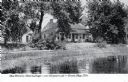
| Description: | View across water toward the Tank Cottage. Caption reads: "The Historic Tank Cottage — over 100 years old — Green Bay, Wis." |

| Date: | 1906 |
|---|---|
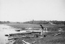
| Description: | Shacks at the foot of North Main Street along Lake Monona near what later became Brittingham Park. |

| Date: | 1906 |
|---|---|
| Description: | Area at the foot of West Main Street, which is now Brittingham Park. Weatherworn buildings are on the right. |

| Date: | 1905 |
|---|---|
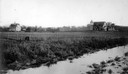
| Description: | View of town behind a prairie field and a lake. Caption reads: "Packwaukee, Wis." |
| Date: | 1908 |
|---|---|
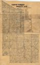
| Description: | Map shows swamps, windfalls, roads and railroads. Status of some land marked (O, S, X) but lacks explanation. |

| Date: | 1908 |
|---|---|
| Description: | Title at top: "G.F. Sanborn Company Timber and Farming Lands." Map shows acreages, roads, railroads, and swamps in parts of Vilas and Oneida counties. |

| Date: | 1902 |
|---|---|
| Description: | Catalog cover in light blue featuring an art nouveau frame in black around an illustration of ducks over marshy water with lilypads and rice plants. A red ... |
| Date: | 1905 |
|---|---|
| Description: | Photographic postcard view of Lake Metonga, with marshy area in foreground. Caption reads: "On Famous Lake Metonga, Crandon, Wis." |

| Date: | 1900 |
|---|---|
| Description: | This photostat of a manuscript map originally drawn in 1829 shows landownership, buildings, including Fort Howard and U.S. sawmill, swamps, public barns an... |

| Date: | 1900 |
|---|---|
| Description: | This map shows portion of the military road from Fond du Lac to the Wisconsin River near Fort Winnebago, with mile markers and adjacent land use. A few pro... |
| Date: | 1907 |
|---|---|
| Description: | Four boats are partially submerged in shallow water by the St. Croix River. |

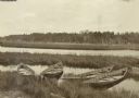
| Date: | 1908 |
|---|---|
| Description: | View of a marshy part of Rock Lake. Two small rowboats and a pile of logs are on the shore, and a flock of ducks is in the water. Caption reads: "Hunting G... |

| Date: | 1906 |
|---|---|
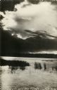
| Description: | Looking toward the Island from a marshy shoreline, Archibald Lake is veiled in a fine mist. Two logs are submerged in the lake in the foreground. Beyond th... |

| Date: | 10 04 1906 |
|---|---|
| Description: | A man is sitting on a rock by a river's edge under trees. Vicinity of Chicago. |

| Date: | 1905 |
|---|---|
| Description: | View from shoreline looking towards two women wearing large hats who are sitting in a carriage drawn by a matched team of horses. The carriage has stopped ... |
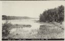
| Date: | 1907 |
|---|---|
| Description: | Text on front reads: "West End, Long Lake, Saxeville, Wis." View of a lake with marshland plants in the foreground. A dock, boat and trees are on the right... |
If you didn't find the material you searched for, our Library Reference Staff can help.
Call our reference desk at 608-264-6535 or email us at: