Filter: Categories of Wisconsin Historical Images
Filter: Subject of Marshes
Filter: Year of 1900-1999
Filter: Year of 1910-1919
Filter: Categories of Wisconsin Historical Images
Filter: Subject of Marshes
Filter: Year of 1900-1999
Filter: Year of 1910-1919
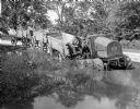
| Date: | 1916 |
|---|---|
| Description: | Man pulling wagons through water with an experimental 8-16(?) tractor with six wheels. |
| Date: | 1910 |
|---|---|
| Description: | Caption reads: "Old Light House at Long Tail Point, Green Bay, Wis." Built in 1859. A marshy area is in the foreground, and a long pier leads to the new li... |

| Date: | 1916 |
|---|---|
| Description: | This Wisconsin Conservation Commission map from 1916 shows Peninsula State Park in the Town of Gibraltar, Door County, Wisconsin. Depicted are open and pla... |

| Date: | 1916 |
|---|---|
| Description: | This version of a 1916 Wisconsin Conservation Commission map shows Peninsula State Park in the Town of Gibraltar, Door County, Wisconsin. Depicted are open... |

| Date: | 1914 |
|---|---|
| Description: | This early 20th century map shows the township and range system, sections, railroads, roads, lakes, wetlands, and streams in the western Sawyer County town... |
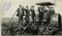
| Date: | 09 08 1914 |
|---|---|
| Description: | Five men in hats and jackets, some holding the levers on a gang plow pulled by a Rumley tractor, pose for a group portrait. One man in work clothes stands ... |

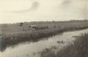
| Date: | 1914 |
|---|---|
| Description: | View of a drainage ditch in Horicon Marsh. A man is on a path along the left of the ditch. |
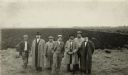
| Date: | 1914 |
|---|---|
| Description: | Group of well-dressed men standing in front of a plowed segment of Horicon Marsh. |

| Date: | 10 1914 |
|---|---|
| Description: | View of furrowed ground in Horicon Marsh and men on a tractor in the process of plowing a drained portion of the marsh. |

| Date: | 1910 |
|---|---|
| Description: | Shows existing and proposed parks, railroads, and marshes in a color coded key. "Contour interval 20 feet." Lake Wingra, Lake Mendota, and Lake Monona are ... |
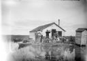
| Date: | 1910 |
|---|---|
| Description: | View across water towards a group of seven men posing on a dock in front of a small hunting shack in the middle of a marsh. Ducks hang on stringers attache... |
| Date: | 1918 |
|---|---|
| Description: | Elevated view across stream in marshy area towards a group of people gathered around an aircraft wreck. |

| Date: | 1911 |
|---|---|
| Description: | This map shows lakes, rivers, swamps, state swamp land, trails and railroads. Includes a township diagram. |

| Date: | 1912 |
|---|---|
| Description: | This map shows a school reserve, swamp land, railroads, and selected buildings. |

| Date: | 1913 |
|---|---|
| Description: | Panoramic slightly elevated view of Winnebago (Ho-Chunk) Indians harvesting cranberries by hand at Gebhart's Marsh. |
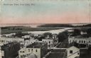
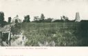
| Date: | 1912 |
|---|---|
| Description: | Bird's-eye view of downtown Fox Lake, with a marshy area and the lake in the background. Caption reads: "Bird's-eye View, Fox Lake, Wis." |
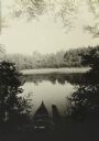
| Date: | 08 1916 |
|---|---|
| Description: | Elevated view looking down at a canoe on the shoreline of the Chippewa River as The Gang takes a well-earned rest. |

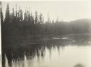
| Date: | 1911 |
|---|---|
| Description: | View from a canoe of a moose feeding in the waters of Sturgeon Lake. The prow of the canoe is in the foreground. |
If you didn't find the material you searched for, our Library Reference Staff can help.
Call our reference desk at 608-264-6535 or email us at: