 Filter: Categories of Wisconsin Historical Images
Filter: Subject of Menominee Indians
Filter: Year of 1900-1999
Filter: Subject of housing
Filter: Categories of Wisconsin Historical Images
Filter: Subject of Menominee Indians
Filter: Year of 1900-1999
Filter: Subject of housing
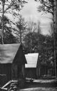
| Date: | 1936 |
|---|---|
| Description: | Exterior view of a logging camp on the Menominee Indian Reservation. The three buildings are surrounded by forest. |

| Date: | 1930 |
|---|---|
| Description: | This map shows rivers, lakes, trails, Indian villages, distances, and boundaries of tracts ceded by the Munnomonee, Winnebaygoes, and New York Indians Trib... |
If you didn't find the material you searched for, our Library Reference Staff can help.
Call our reference desk at 608-264-6535 or email us at: