 Filter: Categories of Wisconsin Historical Images
Filter: Subject of Menominee Indians
Filter: Year of 1900-1999
Filter: Subject of human settlements
Filter: Categories of Wisconsin Historical Images
Filter: Subject of Menominee Indians
Filter: Year of 1900-1999
Filter: Subject of human settlements

| Date: | 1910 |
|---|---|
| Description: | Sawmill on a Menominee Indian reservation, with logs floating in the water in the foreground. Caption reads: "Menominee Indian Mills." |
| Date: | 1920 |
|---|---|
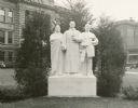
| Description: | "Spirit of the Northwest" monument by Sidney Bedore, on the grounds of the Brown County Court House. Represented, left to right: a Menominee, Claude Alloue... |
| Date: | 1929 |
|---|---|
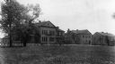
| Description: | The Government Indian School in Keshena. |
| Date: | 1929 |
|---|---|
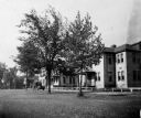
| Description: | The U.S. Department of the Interior, Keshena Indian School. |
| Date: | 1936 |
|---|---|
| Description: | St. Joseph's Indian School on the Keshena Menominee Reservation. |

| Date: | 1935 |
|---|---|
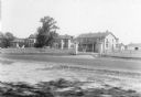
| Description: | Menominee Indian Reservation Government School near Shawano. Caption reads: "Government School, Menominee Indian Reservation, Near Shawano, Wis." |
| Date: | 1935 |
|---|---|
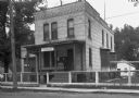
| Description: | U.S. Department of the Indian agency building on the Menominee Indian Reservation. |
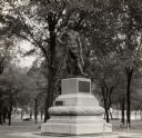
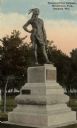
| Date: | 1950 |
|---|---|
| Description: | Oshkosh, head chief of the Menominee Indian Tribe. Side view of the heroic bronze statue by Gaetano Trentanove (Florentine). Unveiled June 21, 1911 in Meno... |
| Date: | 1936 |
|---|---|
| Description: | Chief Oshkosh's statue and grave. Located in Menominee Park, formerly North Park. |
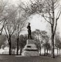
| Date: | 1922 |
|---|---|
| Description: | View of the statue dedicated to Chief Oshkosh of the Menominee Tribe. Sculpted by Trentanove. Located in Menominee Park, formerly North Park. |
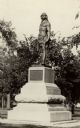
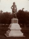
| Date: | 1912 |
|---|---|
| Description: | Statue of Chief Oshkosh of the Menominee Tribe. Sculpted by Trentanove and located in Menominee Park. The statue honors the man who gave his name to the ci... |
| Date: | 1911 |
|---|---|
| Description: | A statue of Oshkosh, head chief of the Menominee Indian Tribe in North Park (Menominee Park). Sculpted by Gaetano Trentanove of Florence, Italy. Unveiled J... |

| Date: | 1938 |
|---|---|
| Description: | This map shows lakes, rivers, roads, trails, lookout towers, and railroads. |

| Date: | 1941 |
|---|---|
| Description: | Wisconsin counties, towns, cities, and selected villages, as well as the Menominee Indian Reservation are identified on this U.S. Bureau of the Census map ... |

| Date: | 1902 |
|---|---|
| Description: | This map shows the railroads of southern Wisconsin with the routes of the Chicago, Milwaukee, and St. Paul Railway traced in red. The township grid, counti... |

| Date: | 1910 |
|---|---|
| Description: | This map of northeastern Wisconsin shows the township grid, counties, cities and villages, lakes, rivers, rail lines and the Menominee Indian Reservation. ... |

| Date: | 1933 |
|---|---|
| Description: | This map shows the township and range system, sections, cities and villages, schools, roads, railroads, and lakes and streams in Shawano County, which at t... |

| Date: | 1956 |
|---|---|
| Description: | This map shows reservation boundaries, U.S. township lines, highways, roads, rivers, and lakes. The lower left corner of the map includes a legend of "Conv... |

| Date: | 1907 |
|---|---|
| Description: | This blueprint map shows a proposed plan for pleasure roads and reservation system. It also shows schools, cemeteries, old river channel, proposed bridge, ... |

| Date: | 1930 |
|---|---|
| Description: | This map shows rivers, lakes, trails, Indian villages, distances, and boundaries of tracts ceded by the Munnomonee, Winnebaygoes, and New York Indians Trib... |
If you didn't find the material you searched for, our Library Reference Staff can help.
Call our reference desk at 608-264-6535 or email us at: