Filter: Categories of Wisconsin Historical Images
Filter: Subject of Michigan, Lake
Filter: Creator Name of Unknown
Filter: Categories of Wisconsin Historical Images
Filter: Subject of Michigan, Lake
Filter: Creator Name of Unknown
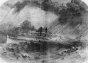
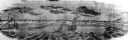
| Date: | 09 22 1860 |
|---|---|
| Description: | Sketch from the "New York Illustrated News" of the sinking of the sidewheel passenger, Lady Elgin. She was struck and sunk by the Augusta on ... |

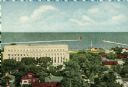
| Date: | 1905 |
|---|---|
| Description: | Bird's-eye view of Manitowoc on the shores of Lake Michigan. A map of the northeastern part of the United States at the top indicates Manitowoc's location ... |
| Date: | |
|---|---|
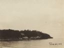
| Description: | Eagle Harbor, looking west, with boats anchored in the harbor. In the foreground are the stone pillars of the village fire station. |
| Date: | 10 1844 |
|---|---|
| Description: | View from a pile-driver on the north pier of the community then known as Southport. The pier visible at left center, constructed between 1840-1842, was th... |
| Date: | 1914 |
|---|---|
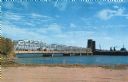
| Description: | View of Sturgeon Bay with the Teweles & Brandeis flour mill across the water on the left. |
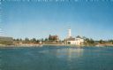
| Date: | |
|---|---|
| Description: | View of a U.S. lighthouse and Coast Guard station. |

| Date: | 1875 |
|---|---|
| Description: | The harbor piers and the entrance to the Sturgeon Bay ship canal. Men are standing on the shoreline. |
| Date: | |
|---|---|
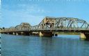
| Description: | View of the bridge spanning the Sturgeon Bay canal. |
| Date: | |
|---|---|
| Description: | View from the shoreline of a bridge spanning the Sturgeon Bay canal. |

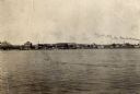
| Date: | 1909 |
|---|---|
| Description: | View of a boating scene off of the shore of Marinette and Menominee. Two boys are walking on the pier on the left, and a crowd of people are gathered at th... |
| Date: | 1900 |
|---|---|
| Description: | View across water of a dock and buildings on Lake Michigan. |

| Date: | 1838 |
|---|---|
| Description: | Compiled from the latest authorities. Published by Hinman and Dutton. |

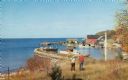
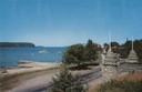
| Date: | 1954 |
|---|---|
| Description: | View looking west from Eagle Bluff toward Nicolet Bay, the Strawberry Islands, and Chambers Island. Three people are sitting on the stone wall of the overl... |

| Date: | 1960 |
|---|---|
| Description: | View across water towards the 180-foot high Eagle Bluff. The bluff received its name from the eagles which formerly nested there. |

| Date: | 1960 |
|---|---|
| Description: | View across water towards the 180-foot high Eagle Bluff. The bluff received its name from the eagles which formerly nested there. |

| Date: | 1910 |
|---|---|
| Description: | Elevated view over trees and bushes toward the footbridge. A building with a red roof is on the far right. Beyond the bridge is Lake Michigan. Caption read... |

| Date: | 1910 |
|---|---|
| Description: | Path along Lake Michigan beach. Below are people walking along the shoreline. Further down the path is a small group of people. Pilings are in the water in... |
If you didn't find the material you searched for, our Library Reference Staff can help.
Call our reference desk at 608-264-6535 or email us at: