 Filter: Categories of Wisconsin Historical Images
Filter: Subject of Michigan, Lake
Filter: County of Kenosha
Filter: Categories of Wisconsin Historical Images
Filter: Subject of Michigan, Lake
Filter: County of Kenosha

| Date: | 1857 |
|---|---|
| Description: | This map shows land ownership by name, local streets, wards, buildings, parks, a cemetery, and part of Lake Michigan. Depths are shown by soundings and nor... |
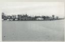
| Date: | 12 09 1957 |
|---|---|
| Description: | Turning basin, view east from ex-Haas property. There is a water tower on the right, and houses, boathouses and other buildings are along the shoreline to ... |

| Date: | |
|---|---|
| Description: | Aerial photograph of the Port of Kenosha and factories, with snow on the ground. There are four ships along the shoreline, and multiple factories on either... |

| Date: | 07 19 1854 |
|---|---|
| Description: | This map shows the shore in 1844, 1850, and 1852, the length of and proposed additions to the pier. Relief is shown by hachures and depths are shown by sou... |

| Date: | 07 19 1854 |
|---|---|
| Description: | This hand-colored map shows the North and South Pier, the North Pier Bridge, the present Channel, and the Channel to be dredged. Lake Michigan and a light ... |

| Date: | 1857 |
|---|---|
| Description: | This map with north oriented toward the lower left shows the United States North and South Piers. Lake shores from 1855, 1856, and 1857 are labeled. Depths... |

| Date: | 1959 |
|---|---|
| Description: | This map shows public access sites, public beaches and parks, other public shorelines, boat liveries, public hunting and fishing grounds, railroads, roads,... |
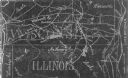
| Date: | 1954 |
|---|---|
| Description: | This photocopy map shows a early sketch of the settlement Southport. Rivers, lakes, other settlements, county boundaries, and roads are labeled. A portion ... |

| Date: | 1926 |
|---|---|
| Description: | This blueprint map shows the harbor at Kenosha, also showing buildings surrounding the harbor, roads, and railroads. Original caption in red states: "Areas... |

| Date: | 1967 |
|---|---|
| Description: | View from behind of two men sitting on a park bench who are looking at the lake steamer docked in the harbor. In the distance, a red lighthouse is at the e... |

| Date: | |
|---|---|
| Description: | View toward the two lighthouses on either side of Kenosha Harbor. The lighthouse on the right has an elevated walkway to the entrance. Caption reads: "Ligh... |

| Date: | |
|---|---|
| Description: | Illustration of a view across water towards a lighthouse and adjoining dwelling. Small boats are moored in the harbor. Caption reads: "The Old Government L... |

| Date: | |
|---|---|
| Description: | Illustration of view across water towards a lighthouse and surrounding buildings. Caption reads: "U.S. Light House, Kenosha, Wis." |

| Date: | 1968 |
|---|---|
| Description: | Rear view of a young boy leaning against a metal railing watching the ships in a harbor. A large cargo ship is in the harbor. A smaller boat, "Morelli," is... |

| Date: | 1955 |
|---|---|
| Description: | Wind Point Lighthouse surrounded by outbuildings and framed by trees. Lake Michigan is in the distance. |
If you didn't find the material you searched for, our Library Reference Staff can help.
Call our reference desk at 608-264-6535 or email us at: