 Filter: Categories of Wisconsin Historical Images
Filter: Subject of Michigan, Lake
Filter: Reproduction Rights of For Sale
Filter: Categories of Wisconsin Historical Images
Filter: Subject of Michigan, Lake
Filter: Reproduction Rights of For Sale
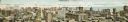
| Date: | 1910 |
|---|---|
| Description: | Panoramic bird's-eye view of the heart of the Loop. Labeled sites include: Insurance Exchange, Continental and Commercial National Bank, Post Office, Dear... |
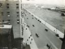
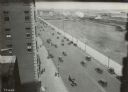
| Date: | 1921 |
|---|---|
| Description: | Elevated view of pedestrians and automobiles on Michigan Avenue from a window in the International Harvester building. Grant Park is across the street. |
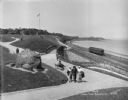
| Date: | 08 06 1917 |
|---|---|
| Description: | Chicago and North Western Railrod depot at the east end of Wisconsin Avenue. Caption on glass plate reads: "South end of Juneau Park extention [sic]... |
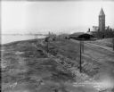
| Date: | 08 06 1917 |
|---|---|
| Description: | Overlooking the Chicago and North Western railroad depot from Juneau Park bluff. Caption on glass plate reads: "Extention [sic] of Juneau Park, show... |
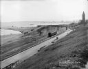
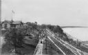
| Date: | 05 30 1914 |
|---|---|
| Description: | Juneau Park looking north from approximately E. Mason Street, with the Chicago and North Western railroad tracks on the right. The Lake Michigan shoreline ... |
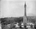
| Date: | 06 19 1902 |
|---|---|
| Description: | Elevated view of the North Point Water Tower at the foot of E. North Avenue. |

| Date: | 1854 |
|---|---|
| Description: | Bird's-eye illustration of Milwaukee. |

| Date: | |
|---|---|
| Description: | Elevated view southeast from the courthouse at E. Kilbourn Avenue and N. Jackson Street. The Northwestern Mutual home office building and Chicago and North... |

| Date: | 1912 |
|---|---|
| Description: | Large crowd of passengers on the whaleback excursion steamer "Christopher Columbus". |
| Date: | 07 31 1921 |
|---|---|
| Description: | Lily E., a schooner converted to the South Shore Yacht Club's floating club house, until the winter of 1921. The club house is at the foot of Nock Street i... |

| Date: | 09 1918 |
|---|---|
| Description: | Elevated view of the U.S. Government War Exposition grounds at Grant Park. |
| Date: | 1921 |
|---|---|
| Description: | Elevated view of Grant Park and cars on the adjacent street taken from the International Harvester offices. |
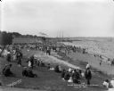
| Date: | 07 31 1921 |
|---|---|
| Description: | Crowds of individuals along South Shore Beach in the Bay View neighborhood. Some individuals are swimming while others are sitting on the grass and sand. ... |
| Date: | 1914 |
|---|---|
| Description: | Elevated view of Pabst Whitefish Bay Resort on the shores of Lake Michigan, with crowds of individuals walking up the numerous paths that lead to the resor... |
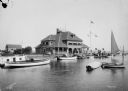
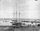
| Date: | 08 01 1914 |
|---|---|
| Description: | Milwaukee Yacht Club, located at the foot of E. Layfayette Street on Lake Michigan. Numerous sailboats are in the harbor, and individuals are on the pier. |

| Date: | 07 26 1914 |
|---|---|
| Description: | A group, mostly youth, on the shores of Lake Michigan at South Shore beach in the Bay View neighborhood. Caption on glass plate reads, "On the Sands, South... |

| Date: | |
|---|---|
| Description: | Elevated view looking northeast from the roof of the Wells Building at E. Wisconsin Avenue and N. Milwaukee Street. St. John's Cathedral is in the center o... |

| Date: | 1852 |
|---|---|
| Description: | Map reads: "The State of Wisconsin- compiled from the latest authorities". In addition, there is a scale which is six miles for every inch, and a profile o... |

| Date: | |
|---|---|
| Description: | Map reads: "Historic and Scenic Wisconsin — Land of Gathering Waters." In an inset there is a hand-painted depiction of the Wisconsin State Seal. For some ... |

| Date: | 1842 |
|---|---|
| Description: | Map reads: "Wisconsin". The map depicts the counties as of 1842 and the various areas of Indian settlements. The scale is twenty miles for every inch. |
If you didn't find the material you searched for, our Library Reference Staff can help.
Call our reference desk at 608-264-6535 or email us at: