Filter: Categories of Wisconsin Historical Images
Filter: Subject of Michigan, Lake
Filter: Subject of bridges
Filter: Categories of Wisconsin Historical Images
Filter: Subject of Michigan, Lake
Filter: Subject of bridges

| Date: | 1872 |
|---|---|
| Description: | Bird's-eye map of Milwaukee on Lake Michigan. |

| Date: | 1927 |
|---|---|
| Description: | Color map, hand-drawn with comic figures engaged in various activities throughout map. Bordered by the river on the left and Lake Michigan on the right, in... |

| Date: | 1874 |
|---|---|
| Description: | Bird's-eye map of Racine, with an inset of Racine College. |

| Date: | 1893 |
|---|---|
| Description: | Bird's-eye map of Sturgeon Bay, looking Northeast. Area bordered by Church Street in top left corner, leather & Smith Bridge in bottom left corner, Lawrenc... |

| Date: | 1879 |
|---|---|
| Description: | Bird's-eye map of Two Rivers. |

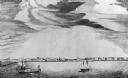
| Date: | 1854 |
|---|---|
| Description: | Bird's-eye view of Milwaukee looking east toward Lake Michigan from a bluff, long since graded into a slope, at about 6th Street between Wisconsin Avenue a... |

| Date: | 1892 |
|---|---|
| Description: | Bird's-eye view of Chicago, with ships in the Lake Michigan harbor. |

| Date: | 05 15 1897 |
|---|---|
| Description: | Elevated view of the Chicago & Northwestern Railway yards looking northwest. The elevator of the Northern Grain Company is in the middle distance. |

| Date: | 1892 |
|---|---|
| Description: | Bird's-eye view of the Columbian Exposition pavilions from the vantage point of Lake Michigan. Included is an inset of the Union Passenger Station (now Uni... |
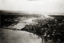
| Date: | 1925 |
|---|---|
| Description: | Aerial view of Green Bay, including the Jorgensen-Blesch Company building and two bridges. |
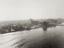
| Date: | 1920 |
|---|---|
| Description: | Aerial view of with bridges, river, and shoreline. |
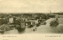
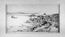
| Date: | 1900 |
|---|---|
| Description: | Elevated view of east Green Bay harbor with cargo ships, W.W. Cagill Co., and other various industries. |
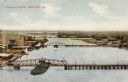
| Date: | 1910 |
|---|---|
| Description: | Elevated view of the harbor entrance. Caption reads: "Harbor Entrance, Green Bay, Wis." |
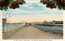
| Date: | 1920 |
|---|---|
| Description: | View of two automobiles crossing a toll bridge. There are cherries on branches at the top of the postcard. Caption reads: "In Door County 'Cherryland,' The... |

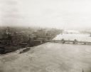
| Date: | 1950 |
|---|---|
| Description: | An aerial view of town, showing a major industrial area. |
If you didn't find the material you searched for, our Library Reference Staff can help.
Call our reference desk at 608-264-6535 or email us at: