 Filter: Categories of Wisconsin Historical Images
Filter: Subject of Michigan, Lake
Filter: Subject of business
Filter: Categories of Wisconsin Historical Images
Filter: Subject of Michigan, Lake
Filter: Subject of business
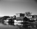
| Date: | 05 05 1963 |
|---|---|
| Description: | View across water towards two fishing boats moored at a dock. |

| Date: | 1836 |
|---|---|
| Description: | This map shows settlers houses and businesses, trails, and swamps. The relief is shown by hachures. The map includes illustrations of historical buildings ... |

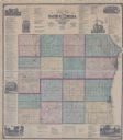
| Date: | 1863 |
|---|---|
| Description: | Includes index to public buildings, churches, schools. Inset: Glidden & Lockwood’s addition. Gives names of some property owners. |

| Date: | 1956 |
|---|---|
| Description: | Intended for tourists, this brochure features a map of Milwaukee's central business district as well as general information about parking, beaches and othe... |

| Date: | 1910 |
|---|---|
| Description: | This map is a survey of Kenosha Harbor and shows local streets, public buildings, local businesses, and part of Lake Michigan. Included is text on sailing ... |

| Date: | 1855 |
|---|---|
| Description: | This map shows lot and block numbers, buildings, some landownership, roads, railroads, cemeteries, the Milwaukee River, and Lake Michigan. The map includes... |
| Date: | 1873 |
|---|---|
| Description: | This hand-colored map includes business directories, a statistical table, as well as illustrations of public, residential, and commercial properties. Commu... |
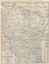
| Date: | 1922 |
|---|---|
| Description: | This map shows roads, highways, lakes, rivers, county boundaries, and cities. Selected businesses are highlighted in red. Includes an explanation of state ... |
If you didn't find the material you searched for, our Library Reference Staff can help.
Call our reference desk at 608-264-6535 or email us at: