 Filter: Categories of Wisconsin Historical Images
Filter: Subject of Michigan, Lake
Filter: Subject of economics
Filter: Categories of Wisconsin Historical Images
Filter: Subject of Michigan, Lake
Filter: Subject of economics

| Date: | 1930 |
|---|---|
| Description: | Page 8 of the 1930 schedule is a map of the routes of the Goodrich Steamship Lines in Lake Michigan and Lake Huron. |
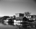
| Date: | 05 05 1963 |
|---|---|
| Description: | View across water towards two fishing boats moored at a dock. |
| Date: | 1893 |
|---|---|
| Description: | Cover of an advertising catalog for William Deering & Company featuring chromolithograph illustrations of the Deering factory, the grain center of the worl... |

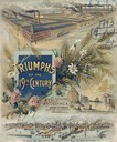
| Date: | 1886 |
|---|---|
| Description: | Cover of an advertising brochure for the Milwaukee Harvester Company featuring a color chromolithograph illustration of a farmer in a field operating a hor... |

| Date: | 1898 |
|---|---|
| Description: | Shows railway lines in Wisconsin marked in red and counties in colors. The meridians are Greenwich, Wisconsin and Washington, Wisconsin. The map folds into... |
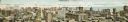
| Date: | 1910 |
|---|---|
| Description: | Panoramic bird's-eye view of the heart of the Loop. Labeled sites include: Insurance Exchange, Continental and Commercial National Bank, Post Office, Dear... |

| Date: | 1868 |
|---|---|
| Description: | Elevated view over rooftops looking towards Lake Michigan shoreline. Seaman's Furniture and Rooms building is surrounded by other commercial buildings. The... |
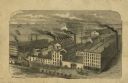
| Date: | 1868 |
|---|---|
| Description: | Engraved illustration of an elevated view of the "McCormick Reaper & Mower Works." Ships are on Lake Michigan in the background. |
| Date: | 1914 |
|---|---|
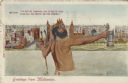
| Description: | Postcard of the Milwaukee lakefront. In the foreground is an image of Neptune standing in Lake Michigan holding a trident in one hand and a beer stein in t... |

| Date: | 1904 |
|---|---|
| Description: | A brochure for the lake region of north-eastern Illinois and south-eastern Wisconsin providing information on summer activities and places to stay in the a... |

| Date: | 1836 |
|---|---|
| Description: | This map shows settlers houses and businesses, trails, and swamps. The relief is shown by hachures. The map includes illustrations of historical buildings ... |

| Date: | 1863 |
|---|---|
| Description: | Includes index to public buildings, churches, schools. Inset: Glidden & Lockwood’s addition. Gives names of some property owners. |
| Date: | 1892 |
|---|---|
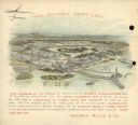
| Description: | Back cover of calendar, with the text: "Hail Columbia, Happy Land!" Features a bird's-eye illustration of the 1893 World's Columbian Exposition (World's Fa... |

| Date: | 1956 |
|---|---|
| Description: | Intended for tourists, this brochure features a map of Milwaukee's central business district as well as general information about parking, beaches and othe... |

| Date: | 1910 |
|---|---|
| Description: | This map is a survey of Kenosha Harbor and shows local streets, public buildings, local businesses, and part of Lake Michigan. Included is text on sailing ... |

| Date: | 1855 |
|---|---|
| Description: | This map shows lot and block numbers, buildings, some landownership, roads, railroads, cemeteries, the Milwaukee River, and Lake Michigan. The map includes... |
| Date: | 1940 |
|---|---|
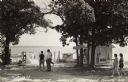
| Description: | Black and white photographic postcard of people on the shoreline and on the pier at Death's Door. Signs on a tree near a snack stand on the right read: "Sm... |

| Date: | 1883 |
|---|---|
| Description: | This map shows lots, neighborhood additions and subdivisions (some in blue, green, pink, and yellow), and numbered wards. Streets, Lake Michigan, and the R... |
| Date: | 01 06 1958 |
|---|---|
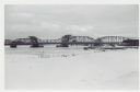
| Description: | View from snowy shoreline of Highway Bridge, the east approach. The lake is frozen. Just beyond the shoreline a boat is moored at a landing, and an automob... |

| Date: | 1903 |
|---|---|
| Description: | This map shows lakes, roads, railroads, townships, and land ownership by name. Counties are colored red, blue, or yellow. Lake Michigan is labeled. Also in... |
If you didn't find the material you searched for, our Library Reference Staff can help.
Call our reference desk at 608-264-6535 or email us at: