 Filter: Categories of Wisconsin Historical Images
Filter: Subject of Michigan, Lake
Filter: Subject of ferries
Filter: Categories of Wisconsin Historical Images
Filter: Subject of Michigan, Lake
Filter: Subject of ferries
| Date: | |
|---|---|
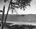
| Description: | View from shoreline towards the screw ferry, "Ann Arbor No. 7." The ferry was later named "Viking," then "Viking I." |
| Date: | |
|---|---|
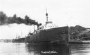
| Description: | The screw ferry, Ann Arbor No. 7, at Frankfort. Later named Viking, then Viking I. Caption reads: "Frankfort, Mich." |
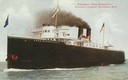
| Date: | 1905 |
|---|---|
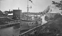
| Description: | The screw rail ferry, Pere Marquette 18. Flags are flying, including one with her name and the American flag. This was Chicago's largest excursion b... |
| Date: | |
|---|---|
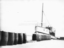
| Description: | The screw ferry, "Wisconsin," docked at Washington Island. Twenty-one metal drums line the edge of the dock in the foreground. Original is in scrapbook on ... |
| Date: | 09 1947 |
|---|---|
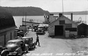
| Description: | Slightly elevated view of people waiting for the ferry at the Gill's Rock landing in Door County. Caption reads: "Scene at Gill's Rock Landing, Door County... |

| Date: | 1929 |
|---|---|
| Description: | Ferryboat landing, with the boats providing service between Gills Rock and Washington Island. |

| Date: | 08 24 1964 |
|---|---|
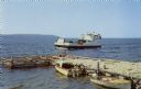
| Description: | View from shoreline of two ferry boats in Lake Michigan. These two boats were once used as Mackinac Straits ferry boats and were later used as potato packi... |
| Date: | |
|---|---|
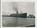
| Description: | Elevated view of the "City of Charlevoix" ship coming into harbor. The sign painted on the front of the ship reads: "Northern Michigan Line" and "City of C... |

| Date: | 1939 |
|---|---|
| Description: | This nine-part map from the U.S. Bureau of Public Roads identifies federal and state highways in Wisconsin by pavement type. County, forest, park, and publ... |

| Date: | 1944 |
|---|---|
| Description: | This nine-part map from the U.S. Bureau of Public Roads identifies federal and state highways in Wisconsin by pavement type. County, forest, park, and publ... |

| Date: | 1950 |
|---|---|
| Description: | This road map shows federal, state and county roads in Wisconsin, northern Illinois, northeastern Iowa, eastern Minnesota, and the western portion of Michi... |

| Date: | 1966 |
|---|---|
| Description: | A colored map depiction of Door County, Wisconsin, with pictorial highlights, titled: "Door County — Wisconsin's Air Conditioned Peninsula Playground." |
| Date: | 1961 |
|---|---|
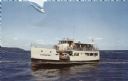
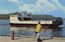
| Description: | Color postcard view of the "Voyageur," a car and passenger ferry operating between mainland Door County and Washington Island. Two motorboats are moored on... |
| Date: | 1950 |
|---|---|
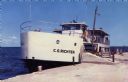
| Description: | Color photographic postcard of the "C.G. Richter," a ferry operating between mainland Door County and Washington Island in Wisconsin. |
| Date: | 1950 |
|---|---|
| Description: | Color photographic postcard view of the "C.G. Richter" at the dock, a ferry operating between mainland Door County and Washington Island. |
| Date: | 1950 |
|---|---|
| Description: | View from dock towards the Washington Island Ferry, "Eyrarbakki." There is a person sitting on a post on the dock. |
| Date: | 09 15 1960 |
|---|---|
| Description: | View across water towards a carferry named "City of Flint," moored at a dock. There are buildings on the dock on the right. |

| Date: | 12 17 1957 |
|---|---|
| Description: | Carferry slip with pilings in the foreground, and a shoreline in the background. The pier is made of timbers. In the background on the left is a factory wi... |

| Date: | 1923 |
|---|---|
| Description: | This map shows portions of Minnesota, Iowa, Wisconsin, Illinois, Indiana, Ohio, Michigan, New York, Vermont, Massachusetts, Connecticut, Ontario, and Quebe... |

| Date: | 1900 |
|---|---|
| Description: | This map shows the boundary lines between ceded and unceded land in compliance with the Treaty of Prairie du Chen of 1829. It also shows roads, rivers, por... |
If you didn't find the material you searched for, our Library Reference Staff can help.
Call our reference desk at 608-264-6535 or email us at: