Filter: Categories of Wisconsin Historical Images
Filter: Subject of Michigan, Lake
Filter: Subject of intellectual life
Filter: Type of Photograph
Filter: Categories of Wisconsin Historical Images
Filter: Subject of Michigan, Lake
Filter: Subject of intellectual life
Filter: Type of Photograph
| Date: | |
|---|---|
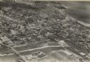
| Description: | Aerial view of buildings with Lake Michigan in the distance. |

| Date: | 11 16 2001 |
|---|---|
| Description: | Aerial view of General Mitchell International in Milwaukee, looking southeast to the Lake Michigan shoreline. |
| Date: | 1925 |
|---|---|
| Description: | Aerial view of Green Bay, including the Jorgensen-Blesch Company building and two bridges. |
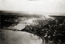
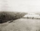
| Date: | 1920 |
|---|---|
| Description: | Aerial view of with bridges, river, and shoreline. |

| Date: | 1950 |
|---|---|
| Description: | An aerial view of town, showing a major industrial area. |

| Date: | 04 01 1975 |
|---|---|
| Description: | The bridge over the Milwaukee Harbor named in honor of former Mayor Daniel Hoan. The bridge was constructed between 1970 and 1972, but during the period de... |

| Date: | 1854 |
|---|---|
| Description: | Bird's-eye illustration of Milwaukee. |

| Date: | 09 1918 |
|---|---|
| Description: | Elevated view of the U.S. Government War Exposition grounds at Grant Park. |

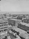
| Date: | |
|---|---|
| Description: | Elevated view looking northeast from the roof of the Wells Building at E. Wisconsin Avenue and N. Milwaukee Street. St. John's Cathedral is in the center o... |
| Date: | 09 1918 |
|---|---|
| Description: | Elevated view of the U.S. Government War Exposition at Grant Park taken from a window the International Harvester building on Michigan Avenue. A large sign... |

| Date: | 09 1918 |
|---|---|
| Description: | Elevated view of the U.S. Government War Exposition at Grant Park taken from a window the International Harvester building on Michigan Avenue. A large crow... |
| Date: | 09 1918 |
|---|---|
| Description: | Elevated view of the U.S. Government War Exposition at Grant Park taken from a window the International Harvester building on Michigan Avenue. A large crow... |

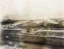
| Date: | 1951 |
|---|---|
| Description: | Aerial view of Jones Island and garbage disposal plant. |

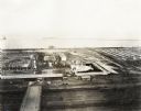
| Date: | 1950 |
|---|---|
| Description: | Harbor area of Jones Island and garbage disposal plant, Stratton Grain Co., and more. |
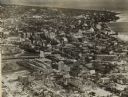
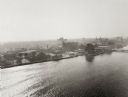
| Date: | |
|---|---|
| Description: | Aerial view looking north of downtown, with the Milwaukee River and Lake Michigan. |
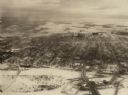
| Date: | 1938 |
|---|---|
| Description: | Aerial view of rivers, with Lake Michigan in upper right, train yards, and highway in lower left. |
If you didn't find the material you searched for, our Library Reference Staff can help.
Call our reference desk at 608-264-6535 or email us at: