Filter: Categories of Wisconsin Historical Images
Filter: Subject of Michigan, Lake
Filter: Subject of michigan, lake
Filter: Community of Kenosha
Filter: Categories of Wisconsin Historical Images
Filter: Subject of Michigan, Lake
Filter: Subject of michigan, lake
Filter: Community of Kenosha
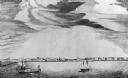
| Date: | 10 1844 |
|---|---|
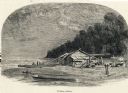
| Description: | A variant of a wood engraving dated October, 1844. Incorporated as the villige of Southport in 1841 (so-named because it was the southern-most natural harb... |
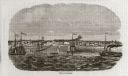
| Date: | 10 1844 |
|---|---|
| Description: | View from a pile-driver on the north pier of the community then known as Southport. The pier visible at left center, constructed between 1840-1842, was th... |

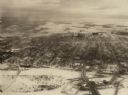
| Date: | 1918 |
|---|---|
| Description: | The Lake Michigan shoreline from Eichelman Park. In the distance is a smokestack and industrial buildings. Caption reads: "Scene on Lake Michigan from Eich... |
| Date: | |
|---|---|
| Description: | Engraving of a wooden shack on a Lake Michigan beach surrounded by rowboats, a campfire, and a wooded bluff. Two men stand on the beach near the water. |

| Date: | 08 31 1963 |
|---|---|
| Description: | View from rock border of a breakwater on Lake Michigan. |

| Date: | 10 19 1836 |
|---|---|
| Description: | This 1836 manuscript map shows the sections, windfalls, marshes, streams, prairies, acreages, and former mouth of the Pike River in what is now the eastern... |

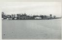
| Date: | 1890 |
|---|---|
| Description: | View from the shore of Kenosha's North Pier and lighthouse. Waves are breaking on the shore of Lake Michigan. |

| Date: | 1855 |
|---|---|
| Description: | This map has relief shown by hachures and soundings and shows local streets, proposed roads, railroads, bridge wharfs, basin, north arm, and west arm of Ke... |

| Date: | 1945 |
|---|---|
| Description: | This map shows wards and precincts and includes a list of polling places by ward and precinct. The map reads: "Keep this Map . . . It Gives the Location of... |

| Date: | 1948 |
|---|---|
| Description: | This map shows wards and precincts and includes a list of polling places by ward and precinct. The map reads: "Keep this Map . . . It Gives the Location of... |

| Date: | 1953 |
|---|---|
| Description: | This map is a blue line print and shows streets as well as some points of interest. |

| Date: | 1948 |
|---|---|
| Description: | This map shows a list of polling places by ward and precinct in the left margin, a list of assembly districts, and additional handwritten notes. Lake Michi... |

| Date: | 1961 |
|---|---|
| Description: | This is a photocopy of a map in blue line print that shows streets and places of interest. Inscribed in pen, at the bottom of the map, reads: "Sen. Zaborsk... |

| Date: | 1857 |
|---|---|
| Description: | This map was created from a survey made in December 1855 and shows local streets, proposed roads, railroads, the lake shore, bridge wharfs, the basin, the ... |

| Date: | 1910 |
|---|---|
| Description: | This map is a survey of Kenosha Harbor and shows local streets, public buildings, local businesses, and part of Lake Michigan. Included is text on sailing ... |

| Date: | 1857 |
|---|---|
| Description: | This map shows land ownership by name, local streets, wards, buildings, parks, a cemetery, and part of Lake Michigan. Depths are shown by soundings and nor... |
| Date: | 12 09 1957 |
|---|---|
| Description: | Turning basin, view east from ex-Haas property. There is a water tower on the right, and houses, boathouses and other buildings are along the shoreline to ... |
If you didn't find the material you searched for, our Library Reference Staff can help.
Call our reference desk at 608-264-6535 or email us at: