Filter: Categories of Wisconsin Historical Images
Filter: Subject of Michigan, Lake
Filter: Subject of michigan, lake
Filter: Subject of transportation
Filter: County of Door
Filter: Categories of Wisconsin Historical Images
Filter: Subject of Michigan, Lake
Filter: Subject of michigan, lake
Filter: Subject of transportation
Filter: County of Door
| Date: | |
|---|---|
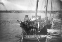
| Description: | View from shoreline towards the screw ferry, "Ann Arbor No. 7." The ferry was later named "Viking," then "Viking I." |
| Date: | |
|---|---|
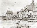
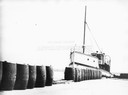
| Description: | The screw ferry, "Wisconsin," docked at Washington Island. Twenty-one metal drums line the edge of the dock in the foreground. Original is in scrapbook on ... |
| Date: | 1888 |
|---|---|
| Description: | Elevated view of men repairing a docked, damaged ship. A shoreline is in the distance. |

| Date: | 1893 |
|---|---|
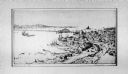
| Description: | Bird's-eye map of Sturgeon Bay, looking Northeast. Area bordered by Church Street in top left corner, leather & Smith Bridge in bottom left corner, Lawrenc... |
| Date: | 09 1947 |
|---|---|
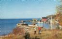
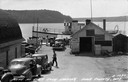
| Description: | Slightly elevated view of people waiting for the ferry at the Gill's Rock landing in Door County. Caption reads: "Scene at Gill's Rock Landing, Door County... |
| Date: | 1935 |
|---|---|
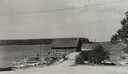
| Description: | View down road towards boats docked at the fishing wharf at Ephraim in Door County. The bluff on the horizon is in Peninsula State Park. |
| Date: | |
|---|---|
| Description: | Eagle Harbor, looking west, with boats anchored in the harbor. In the foreground are the stone pillars of the village fire station. |

| Date: | 1915 |
|---|---|
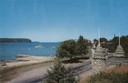
| Description: | View from hill across Eagle Bay with buildings and trees in the foreground. Caption reads: "Across Eagle Bay, Ephraim, Wis." |

| Date: | 1910 |
|---|---|
| Description: | View from hill towards downtown Fish Creek, with the buildings and ground covered in snow. There is a road in the foreground leading off to the left. The b... |

| Date: | 1929 |
|---|---|
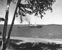
| Description: | Ferryboat landing, with the boats providing service between Gills Rock and Washington Island. |
| Date: | 1967 |
|---|---|
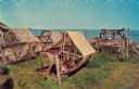
| Description: | Fishing nets drying along the shore of Lake Michigan. |
| Date: | 1920 |
|---|---|
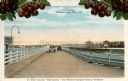
| Description: | View of two automobiles crossing a toll bridge. There are cherries on branches at the top of the postcard. Caption reads: "In Door County 'Cherryland,' The... |

| Date: | 1953 |
|---|---|
| Description: | View across water towards the Sturgeon Bay Canal Lighthouse, with a group of people in a motorboat in the foreground. |
| Date: | 1910 |
|---|---|
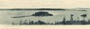
| Description: | View of Sawyer Harbor as seen from Government Bluff. |
| Date: | 1910 |
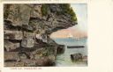
|---|---|
| Description: | View of Lover's Leap, with a group of people posing on the rocks and sailboats in the background. Caption reads: "Lover's Leap, Sturgeon Bay, Wis." |
| Date: | 1910 |
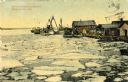
|---|---|
| Description: | A springtime harbor scene from Sturgeon Bay. Chunks of ice are floating on the surface of the water. Caption reads: "Harbor scene at springtime. Sturgeon B... |
If you didn't find the material you searched for, our Library Reference Staff can help.
Call our reference desk at 608-264-6535 or email us at: