 Filter: Categories of Wisconsin Historical Images
Filter: Subject of Michigan, Lake
Filter: Subject of military bases
Filter: Categories of Wisconsin Historical Images
Filter: Subject of Michigan, Lake
Filter: Subject of military bases

| Date: | 1931 |
|---|---|
| Description: | This U.S. Geological Survey map of Wisconsin shows counties, cities and villages, lighthouses, Indian reservations, military reservations, and bird and gam... |
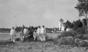
| Date: | 1915 |
|---|---|
| Description: | Six Coastguardsmen pose with an officer on the shore at the Coast Guard Station at Baileys Harbor. The men are identified as (left to right) Reinhart Hicke... |
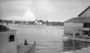
| Date: | 1915 |
|---|---|
| Description: | The Baileys Harbor Coast Guard Life Saving Station viewed from between a fishing boat and a pier warehouse. The station's pier extends into the harbor and ... |
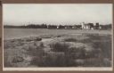
| Date: | 1915 |
|---|---|
| Description: | View from shoreline over water towards the Coast Guard Station and houses at Baileys Harbor. The long pier extending from the station's boathouse is easily... |

| Date: | 1777 |
|---|---|
| Description: | Map of Colonial America east of Lake Michigan showing regions, cities, forts, Native American land, mountains, lakes, and rivers. Crossed swords and small ... |

| Date: | 1720 |
|---|---|
| Description: | Map showing the course of the Mississippi River from the Gulf of Mexico up past Lake Superior into Canada. It shows the towns, Native American tribes and l... |

| Date: | 1755 |
|---|---|
| Description: | Map of the Great Lakes region during the French and Indian War. It shows in great detail the territories, borders and boundary lines, Native American tribe... |
If you didn't find the material you searched for, our Library Reference Staff can help.
Call our reference desk at 608-264-6535 or email us at: