Filter: Categories of Wisconsin Historical Images
Filter: Subject of Michigan, Lake
Filter: Subject of service industries
Filter: Categories of Wisconsin Historical Images
Filter: Subject of Michigan, Lake
Filter: Subject of service industries
| Date: | 1962 |
|---|---|
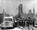
| Description: | Sailors passing cases of bottled Coca-Cola (soda) from an International truck to a ship docked at Chicago. City skyline in background. |
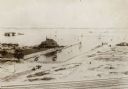
| Date: | 05 05 1963 |
|---|---|
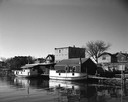
| Description: | View across water towards two fishing boats moored at a dock. |

| Date: | 1898 |
|---|---|
| Description: | Bird's-eye map of Milwaukee with prominent streets and buildings identified. Taken from City Hall Tower. |

| Date: | 1927 |
|---|---|
| Description: | Color map, hand-drawn with comic figures engaged in various activities throughout map. Bordered by the river on the left and Lake Michigan on the right, in... |
| Date: | 1936 |
|---|---|
| Description: | Crescent Beach campsite with cabins and miniature golf course by Lake Michigan. |

| Date: | 1856 |
|---|---|
| Description: | The Ludemann's [also spelled Lueddemann] farm had been cultivated since the early 1850s by Mr. Ludemann, "a very pleasant Saxon with his very pleasant wife... |
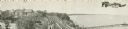
| Date: | 1900 |
|---|---|
| Description: | Elevated view of the Pabst Whitefish Bay Resort. |
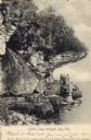
| Date: | 1906 |
|---|---|
| Description: | View of Lover's Leap with a group of people on the rocks near the shoreline under an overhang. Caption reads: "Lovers Leap, Sturgeon Bay, Wis." |
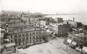
| Date: | 1898 |
|---|---|
| Description: | Elevated view of the downtown area looking northeast from the courthouse corner. |

| Date: | 1909 |
|---|---|
| Description: | [Lithography] by Poole Bros. Contains descriptive information. Short jaunts for busy people to nearby resorts in Illinois and Wisconsin. |

| Date: | 1898 |
|---|---|
| Description: | Shows railway lines in Wisconsin marked in red and counties in colors. The meridians are Greenwich, Wisconsin and Washington, Wisconsin. The map folds into... |

| Date: | 1954 |
|---|---|
| Description: | View looking west from Eagle Bluff toward Nicolet Bay, the Strawberry Islands, and Chambers Island. Three people are sitting on the stone wall of the overl... |
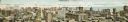
| Date: | 1910 |
|---|---|
| Description: | Panoramic bird's-eye view of the heart of the Loop. Labeled sites include: Insurance Exchange, Continental and Commercial National Bank, Post Office, Dear... |
| Date: | 1914 |
|---|---|
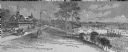
| Description: | Elevated view of Pabst Whitefish Bay Resort on the shores of Lake Michigan, with crowds of individuals walking up the numerous paths that lead to the resor... |

| Date: | |
|---|---|
| Description: | Map reads: "Historic and Scenic Wisconsin — Land of Gathering Waters." In an inset there is a hand-painted depiction of the Wisconsin State Seal. For some ... |

| Date: | 1951 |
|---|---|
| Description: | Aerial view of Jones Island and garbage disposal plant. |

| Date: | 1950 |
|---|---|
| Description: | Harbor area of Jones Island and garbage disposal plant, Stratton Grain Co., and more. |
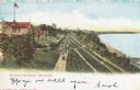
| Date: | 1895 |
|---|---|
| Description: | View from across railroad tracks. Resort is on the water's edge, with a small inlet on the right. Land is mostly sand, though a small part on the left ha... |
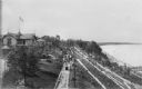
| Date: | 1905 |
|---|---|
| Description: | Elevated view of people walking on a path by the Whitefish Bay Resort along the lake front. Caption reads: "Whitefish Bay Resort, Milwaukee." |
If you didn't find the material you searched for, our Library Reference Staff can help.
Call our reference desk at 608-264-6535 or email us at: