 Filter: Categories of Wisconsin Historical Images
Filter: Subject of Michigan, Lake
Filter: Subject of street-railroads
Filter: Categories of Wisconsin Historical Images
Filter: Subject of Michigan, Lake
Filter: Subject of street-railroads

| Date: | 1927 |
|---|---|
| Description: | Color map, hand-drawn with comic figures engaged in various activities throughout map. Bordered by the river on the left and Lake Michigan on the right, in... |
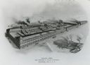
| Date: | 1900 |
|---|---|
| Description: | Main factory with South Foundry in lower left. Lake Michigan is in the background. Later the Allis-Chalmers Manufacturing Co. |

| Date: | 1922 |
|---|---|
| Description: | A road map of Milwaukee County, Wisconsin that shows the township and range system, towns, communities, completed roads, a proposed system of roads, steam ... |

| Date: | 1880 |
|---|---|
| Description: | Map created from original drawing and surveys taken by Silas Chapman. Bottom right corner features a reference key. There is a street guide on the left sid... |

| Date: | 1931 |
|---|---|
| Description: | This map is an advertisement for Milwaukee street cars and motor buses and reads: "Ride the street car or motor bus. Economical, safe, dependable." Include... |

| Date: | 1960 |
|---|---|
| Description: | Color coded map in pink, yellow, blue, and brown of Milwaukee County State and County trunk highways. The map includes a legend of symbols: "STEAM RAIL ROA... |

| Date: | 1938 |
|---|---|
| Description: | Color coded map in pink, yellow, blue, and brown of Milwaukee County State and County trunk highways. The map includes a legend of symbols: "STEAM RAIL ROA... |

| Date: | 1948 |
|---|---|
| Description: | This map of Milwaukee and surrounding suburbs includes an index to the orange bus, rapid transit, street car, trackless trolley, and the green bus lines. T... |

| Date: | 1936 |
|---|---|
| Description: | Street map of the City of Milwaukee and surrounding suburbs indicating various mass transit lines. There is an index to Milwaukee streets at the right of t... |

| Date: | 1897 |
|---|---|
| Description: | Two maps that show cemeteries, schools, engine houses, railroads, street railways, wards, roads, parks, block numbers, and Lake Michigan. One map has wards... |

| Date: | 1912 |
|---|---|
| Description: | This map shows counties, roads, Lake Superior, Lake Michigan, and a portion of Illinois, Iowa, Minnesota, and Michigan. Also included is a list of railroad... |
If you didn't find the material you searched for, our Library Reference Staff can help.
Call our reference desk at 608-264-6535 or email us at: