 Filter: Categories of Wisconsin Historical Images
Filter: Subject of Michigan, Lake
Filter: Subject of trails
Filter: Categories of Wisconsin Historical Images
Filter: Subject of Michigan, Lake
Filter: Subject of trails
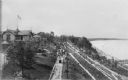
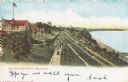
| Date: | 1914 |
|---|---|
| Description: | Elevated view of Pabst Whitefish Bay Resort on the shores of Lake Michigan, with crowds of individuals walking up the numerous paths that lead to the resor... |
| Date: | |
|---|---|
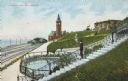
| Description: | Train station in the distance, with a man standing in the foreground on steps leading down to the lake, near a fenced-in pond. On the left are railroad tra... |

| Date: | 1940 |
|---|---|
| Description: | Monument in Juneau Park. A man is sitting on a bench, with Lake Michigan behind. |
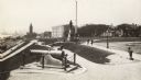
| Date: | 1910 |
|---|---|
| Description: | A canon is in the foreground to the left. There are a number of pedestrians in the park and on the path by the lake. In the background on the left is a tra... |
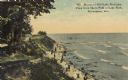
| Date: | 1910 |
|---|---|
| Description: | Path along Lake Michigan beach. Below are people walking along the shoreline. Further down the path is a small group of people. Pilings are in the water in... |

| Date: | |
|---|---|
| Description: | View looking down toward a curving stairway leading down to a terrace with columns and ornate railings. In the background is a flagpole on the overlook to ... |

| Date: | |
|---|---|
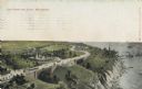
| Description: | View down curving road lined with flowering bushes toward a bridge in Lake Park. Lake Michigan is in the distance, with a ship at the horizon. Caption read... |
| Date: | 1905 |
|---|---|
| Description: | Elevated view of people walking on a path by the Whitefish Bay Resort along the lake front. Caption reads: "Whitefish Bay Resort, Milwaukee." |
| Date: | |
|---|---|
| Description: | Elevated view with the lake on the right, with a number of boats near the shoreline. There is a long winding road through the park, including bridges, a fo... |

| Date: | 1930 |
|---|---|
| Description: | This map shows Indian trails through Wisconsin counties. The trail are in red ink. Lake Michigan, Green Bay, Lake Superior, and the Wisconsin River are lab... |

| Date: | 1919 |
|---|---|
| Description: | This map depicts the route of the 1842 overland trip by wagon made by the Reverend Alfred Brunson and some copper miners from Prairie du Chien to the mouth... |

| Date: | 1920 |
|---|---|
| Description: | Shows 10 land and water trails along rivers and other bodies of water in northern Wisconsin and the Upper Peninsula of Michigan; each trail numbered and de... |

| Date: | 1837 |
|---|---|
| Description: | This map shows the townships, roads, trails, natural land forms, vegetation, mill sites and lead and copper deposits in the Wisconsin Territory at the time... |
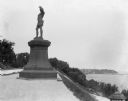
| Date: | 09 1900 |
|---|---|
| Description: | View of a statue in Juneau Park, created by American sculptor Anne Whitney in 1887. The statue is a replica of the original which resides in Boston, Massac... |

| Date: | 1800 |
|---|---|
| Description: | This 19th-century manuscript map of the Town of Newton, Manitowoc County, Wisconsin, shows sections, lakes and streams, the trail from Chicago to Green Bay... |

| Date: | 1835 |
|---|---|
| Description: | Shows Walker’s Point, Juneau Town and Kilbourn Town, including labeled buildings, trails and Indian villages. Relief shown by hachures. Oriented with north... |

| Date: | 1836 |
|---|---|
| Description: | This map shows settlers houses and businesses, trails, and swamps. The relief is shown by hachures. The map includes illustrations of historical buildings ... |

| Date: | 1996 |
|---|---|
| Description: | This map shows roads, lakes, points of interest including colleges, trails, historic communities and sites, museums, and parks. Also included are descripti... |

| Date: | 1942 |
|---|---|
| Description: | This map shows the route of the Milwaukee Road, roads, foot trails, resorts, and ranger stations. The map includes text, illustrations, a railroad fare tab... |

| Date: | 1937 |
|---|---|
| Description: | This is map 4 from a set of 4 taken from an atlas. The map includes a legend in the lower left corner of roads, trails, county lines, town lines, section l... |
If you didn't find the material you searched for, our Library Reference Staff can help.
Call our reference desk at 608-264-6535 or email us at: