Filter: Categories of Wisconsin Historical Images
Filter: Subject of Michigan, Lake
Filter: Year of 1800-1899
Filter: Year of 1880-1889
Filter: Categories of Wisconsin Historical Images
Filter: Subject of Michigan, Lake
Filter: Year of 1800-1899
Filter: Year of 1880-1889

| Date: | 1886 |
|---|---|
| Description: | This map shows U.S. land offices, completed railroads, railroad land grant limits, lakes, rivers, and Indian reservations. Communities, lakes, and rivers a... |
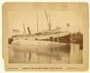
| Date: | 04 20 1888 |
|---|---|
| Description: | The launching of the screw passenger and freight vessel, "Petoskey," on April 20, 1888 at Burger and Burger Builders, Manitowoc, Wisconsin. |
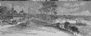
| Date: | 1888 |
|---|---|
| Description: | Elevated view of men repairing a docked, damaged ship. A shoreline is in the distance. |

| Date: | 1886 |
|---|---|
| Description: | Cover of an advertising brochure for the Milwaukee Harvester Company featuring a color chromolithograph illustration of a farmer in a field operating a hor... |

| Date: | 1883 |
|---|---|
| Description: | Bird's-eye map of Manitowoc. |

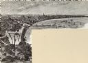
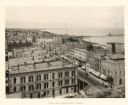
| Date: | 1886 |
|---|---|
| Description: | Bird's-eye view of Milwaukee from Bay View. |
| Date: | 1888 |
|---|---|
| Description: | Elevated view from the Racine Court House of northeast Racine, with Lake Michigan on the right. Caption reads: "Bird's-Eye from Court House." |

| Date: | 1880 |
|---|---|
| Description: | This map shows railroads by operator and projected railroads. Portions of Lake Michigan, Lake Superior, Illinois, Iowa, Michigan and Minnesota are labeled. |

| Date: | 1882 |
|---|---|
| Description: | This basic reference map of the state shows natural features, railroads, county seats, and political boundaries against the G.L.O. township and range grid.... |

| Date: | 1889 |
|---|---|
| Description: | Looking down street toward Lake Michigan, which is visible at the end of the road. The dirt street is lined with trees and houses. On the right stands a... |

| Date: | 1882 |
|---|---|
| Description: | The official railroad map of Wisconsin showing railroad lines throughout the state. |

| Date: | 1884 |
|---|---|
| Description: | The official railroad map of Wisconsin showing railroad lines throughout the state. |

| Date: | 1887 |
|---|---|
| Description: | This map shows block numbers, roads, railroads, wards, and selected buildings. The map includes a "Milwaukee city street guide" and index to public buildin... |

| Date: | 1881 |
|---|---|
| Description: | A hand-colored map of Wisconsin that shows counties, cities, towns, villages, railroads, as well as the locations of railroad stations and post offices wit... |

| Date: | 1880 |
|---|---|
| Description: | Map of Wisconsin including the eastern portions on Minnesota, Iowa, northern Illinois, and the western most portion of Michigan’s Upper Peninsula, showing ... |

| Date: | 1881 |
|---|---|
| Description: | A brochure with a map of Wisconsin that also includes information (in English, German, Norwegian, and Swedish) pertaining to the state, such as its timber ... |

| Date: | 1882 |
|---|---|
| Description: | A geological map of northern Wisconsin showing the locations of different soil types in the state such as sandy soil, sandy loam, prairie loam, clayey loam... |
If you didn't find the material you searched for, our Library Reference Staff can help.
Call our reference desk at 608-264-6535 or email us at: