 Filter: Categories of Wisconsin Historical Images
Filter: Subject of Michigan, Lake
Filter: Categories of Wisconsin Historical Images
Filter: Subject of Michigan, Lake
| Date: | |
|---|---|
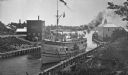
| Description: | Elevated view of the "City of Charlevoix" ship coming into harbor. The sign painted on the front of the ship reads: "Northern Michigan Line" and "City of C... |

| Date: | 1856 |
|---|---|
| Description: | A Wisconsin map showing the Wisconsin Superior and St. Croix Railroad. |

| Date: | |
|---|---|
| Description: | Elevated view toward a small boat landing and pier area on the shore of Lake Michigan. Many men, women and children are on the pier, and a house is on a hi... |
| Date: | 1861 |
|---|---|
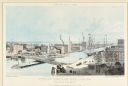
| Description: | Lithograph illustration of downtown Chicago near the Rush Street bridge (a "swing bridge"). The McCormick Reaper Works and other factory buildings are on t... |

| Date: | 1894 |
|---|---|
| Description: | Sanborn Map of the Illinois Steel Co. Bay View Works in Milwaukee. |

| Date: | 1936 |
|---|---|
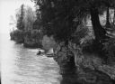
| Description: | Shoreline and wavelets near Red Banks on Lake Michigan. |
| Date: | 1936 |
|---|---|
| Description: | Elevated view of the Lake Michigan shoreline and the rocks at Cave Point. |
| Date: | 1938 |
|---|---|
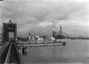
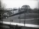
| Description: | View from railroad bridge of the harbor at Green Bay. On the other side of the harbor, there are many industrial buildings, including Northern Paper Mills,... |

| Date: | |
|---|---|
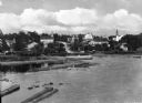
| Description: | Elevated view of Sturgeon Bay with houses in the foreground. |

| Date: | |
|---|---|
| Description: | Elevated view of Sturgeon Bay showing commercial and domestic buildings in the foreground. Photograph made between 1916-1928. |

| Date: | |
|---|---|
| Description: | Elevated view of Sturgeon Bay. The commercial strip and domestic buildings are in the foreground. |
| Date: | 1876 |
|---|---|
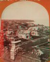
| Description: | Stereograph of a view over rooftops of a neighborhood near Lake Michigan. Shoreline can be seen in the background. |

| Date: | |
|---|---|
| Description: | View of Leathem D. Smith Stone Company, which expanded after 1918. A factory building is in the background, and a steam shovel is working in the foreground... |
| Date: | |
|---|---|
| Description: | View of Eagle Harbor and the area surrounding Church Street. On the right, Ephraim Moravian Church, completed in 1859, can be seen among residential buildi... |
| Date: | |
|---|---|
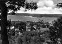
| Description: | View of a residential area of Fish Creek, looking out over Fish Creek Harbor. |
| Date: | 1949 |
|---|---|
| Description: | Holiday card of the Sister Bay lakeshore. Three figures are on the shore. Two boathouses, a covered boat, a pier, and two upright boats are in the backgrou... |
| Date: | 1893 |
|---|---|
| Description: | Elevated view of the Illinois Central World's Fair Transportation Center at Van Buren Street. Several pedestrians cross a bridge leading to trains and lake... |

| Date: | 1936 |
|---|---|
| Description: | An elevated view of Milwaukee Harbor with railroad station looking towards Lake Michigan. |

| Date: | 1968 |
|---|---|
| Description: | This map shows lakes, rivers and soil types. Lake Michigan, Lake Superior, and portions of Illinois, Iowa, Michigan, and Minnesota are labeled. A legend to... |

| Date: | 1912 |
|---|---|
| Description: | This map shows parcel zones, counties, electric lines, and railroads. Includes text and charts about parcel post regulations and laws. Also includes an ins... |
If you didn't find the material you searched for, our Library Reference Staff can help.
Call our reference desk at 608-264-6535 or email us at: