 Filter: Categories of Wisconsin Historical Images
Filter: Subject of Military bases
Filter: Subject of streets
Filter: Categories of Wisconsin Historical Images
Filter: Subject of Military bases
Filter: Subject of streets
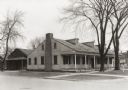
| Date: | 04 09 1934 |
|---|---|
| Description: | View from street towards the Fort Howard Hospital. |

| Date: | 1760 |
|---|---|
| Description: | Map showing upstate New York, Lake Ontario, and the St. Lawrence River during the last, decisive battle of the French and Indian War. The main map shows a ... |

| Date: | 1759 |
|---|---|
| Description: | Map of New Orleans at the start of the French & Indian War, including two inset maps entitled "The Course of the Mississipi River from Bayagoulas to the Se... |

| Date: | 1769 |
|---|---|
| Description: | Map of New Orleans at the start of the French & Indian War, including two inset maps of the Mississippi River Delta and Fort la Balise. It shows streets, r... |
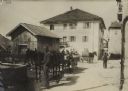
| Date: | |
|---|---|
| Description: | Soldiers relaxing in front of the Folgaria Hotel in Italy. The men are standing around horse-drawn wagons and carts, and other men are walking down a stree... |
If you didn't find the material you searched for, our Library Reference Staff can help.
Call our reference desk at 608-264-6535 or email us at: