 Filter: Categories of Wisconsin Historical Images
Filter: Subject of Mines and mineral resources
Filter: Subject of land
Filter: Categories of Wisconsin Historical Images
Filter: Subject of Mines and mineral resources
Filter: Subject of land

| Date: | 1800 |
|---|---|
| Description: | Map of the United States. It shows the states, including Tennessee, cities, towns, Native American land, mountains, lakes, and rivers. Lead mines appear ju... |

| Date: | 1781 |
|---|---|
| Description: | Map of the Southeastern part of the British Colonies in North America, Gulf Coast and Caribbean. It illustrates the of the Spanish and English fleets, part... |

| Date: | 1720 |
|---|---|
| Description: | Map showing the course of the Mississippi River from the Gulf of Mexico up past Lake Superior into Canada. It shows the towns, Native American tribes and l... |

| Date: | 1766 |
|---|---|
| Description: | Map of the region south of Lake Erie to the Ohio River. It shows forts, towns, Native American towns, mines, roads, mountains, swamps, lakes, and rivers. T... |

| Date: | 1903 |
|---|---|
| Description: | Caption on negative sleeve reads, "Mining (?) town with view of saloon, restaurant and general store." A boardwalk runs along the fronts of the buildings. ... |
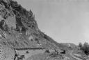
| Date: | 07 1936 |
|---|---|
| Description: | A worker is pulling a wheelbarrow behind him while walking alongside a narrow gauge railroad track at the south end of the East Bluff near Devil's Lake. Em... |

| Date: | |
|---|---|
| Description: | Stereograph of the side view of a mine. Several horse-drawn wagons are waiting for loads with workmen. Hills of soil surround a flat area, and on the horiz... |

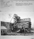
| Date: | 1950 |
|---|---|
| Description: | Subject: "TD-18A — Mines." Where Taken: "NE." Information with photograph reads: "Owned by Jos. F. Sherman, Hawthorne, Pa. Used with Isaacson blade in stri... |
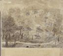
| Date: | 1845 |
|---|---|
| Description: | Drawing of Shullsburg. Text at bottom reads: "Smelting lead ore in log furnaces. Scene in Gratiots Grove at Shullsburg, Wis. in 1845-6. Drawn from life. By... |

| Date: | |
|---|---|
| Description: | Two men are standing in front of the entrance to a mine. Vertical beams are just inside the entrance. The man on the left has a cloth sack draped over his ... |
| Date: | 1950 |
|---|---|
| Description: | View of Coal Mine. Subject: "UD-16 — Generators." Where Taken: "MidW." Information with photograph reads: "Used by the Big 4 Coal Co., Ottumwa, Iowa, to dr... |
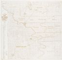
| Date: | 1978 |
|---|---|
| Description: | A map showing allotments of American Indian tribes in Ottawa County, Oklahoma. On the left side is a listing of Lead & Zinc Mines. |
If you didn't find the material you searched for, our Library Reference Staff can help.
Call our reference desk at 608-264-6535 or email us at: