Filter: Categories of Wisconsin Historical Images
Filter: Subject of Mississippi River
Filter: Subject of intellectual life
Filter: Creator Name of Unknown
Filter: Categories of Wisconsin Historical Images
Filter: Subject of Mississippi River
Filter: Subject of intellectual life
Filter: Creator Name of Unknown

| Date: | 1780 |
|---|---|
| Description: | Hand-drawn plan for the layout of the town of Clarksville, bordering Mayfield Creek and Liberty Creek. Fort Jefferson is shown between the townsite and the... |

| Date: | 1875 |
|---|---|
| Description: | Aerial view of Alma along Mississippi River, with bluffs along the horizon. |

| Date: | 1907 |
|---|---|
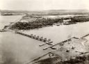
| Description: | Aerial view of the Mississippi River with log rafts. |
| Date: | 1910 |
|---|---|
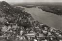
| Description: | Aerial view of town, with a river and the horizon in the distance. |

| Date: | |
|---|---|
| Description: | Caption reads: "Air View — Fountain City, Wis." Aerial view of town and surrounding landscape that includes trees, rolling hills, and a river. |

| Date: | 1925 |
|---|---|
| Description: | Caption reads: "Bird's Eye View of Fountain City, Wis. M-1255". Aerial view of town with the river on the right. |

| Date: | 1925 |
|---|---|
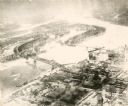
| Description: | Bird's-eye view of Fountain City looking south, with high bluff on the left, and the Mississippi River on the right. Fountain City, about 4 blocks wide, ne... |
| Date: | 1935 |
|---|---|
| Description: | An aerial view of La Crosse and the Mississippi River with the bridge drawn in to show what the finished product would look like. |

| Date: | 1940 |
|---|---|
| Description: | Aerial view of the bridge spanning the Mississippi River in La Crosse. |
| Date: | |
|---|---|
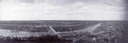
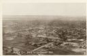
| Description: | Aerial view of La Crosse, with the Mississippi River in the distance. |
| Date: | 1887 |
|---|---|
| Description: | Letterhead of the La Crosse Wallis Carriage Co., manufacturers of fine family carriages, showing a view of the factory with the Mississippi River in the ba... |

| Date: | 04 12 1907 |
|---|---|
| Description: | Photographic postcard of an aerial view of town looking North. The Mississippi River is on the left. |

| Date: | |
|---|---|
| Description: | Memohead of the G. Heileman Brewing Company of La Crosse, Wisconsin, manufacturers of keg and bottled beer, with an elevated view of the brewery complex, i... |

| Date: | |
|---|---|
| Description: | Letterhead of the John Gund Brewing Company of La Crosse, Wisconsin, with an elevated view of the brewery complex on the left. On the right is the company ... |

| Date: | 1874 |
|---|---|
| Description: | A hand-colored, geological map of Wisconsin show the progress of the state geological survey in 1873 and 1874. Other elements displayed in the map include... |

| Date: | 02 1823 |
|---|---|
| Description: | A map featuring the North American expedition from Pittsburgh to the Rocky Mountains led by Edwin James. |

| Date: | 1887 |
|---|---|
| Description: | Map of the Fox and Wisconsin Rivers to accompany Reuben Gold Thwaites' Historic Waterways. |
If you didn't find the material you searched for, our Library Reference Staff can help.
Call our reference desk at 608-264-6535 or email us at: