Filter: Categories of Wisconsin Historical Images
Filter: Subject of Mississippi River
Filter: Subject of intellectual life
Filter: Subject of land
Filter: Categories of Wisconsin Historical Images
Filter: Subject of Mississippi River
Filter: Subject of intellectual life
Filter: Subject of land

| Date: | 1803 |
|---|---|
| Description: | Cours du Mississippi : comprenant la Louisiane, les 2 Florides, une partie des Etats-Unis, et pays adjacents. |

| Date: | 1867 |
|---|---|
| Description: | Bird's-eye map of La Crosse with nine insets of residences, schools, and the Court House and Jail. |

| Date: | 1880 |
|---|---|
| Description: | Bird's-eye map over the Mississippi River of Fountain City. Paddle steamers and steamboats are on the river, and bluffs are in the background. |

| Date: | 1906 |
|---|---|
| Description: | Bird's-eye view of McGregor on the Mississippi River. |

| Date: | 1875 |
|---|---|
| Description: | Aerial view of Alma along Mississippi River, with bluffs along the horizon. |

| Date: | 1907 |
|---|---|
| Description: | Aerial view of the Mississippi River with log rafts. |
| Date: | 1900 |
|---|---|
| Description: | Aerial view of town. The Mississippi River and far shoreline is in the background. The Furnace Branch creek runs through the town in the foreground. |

| Date: | |
|---|---|
| Description: | Caption reads: "Air View — Fountain City, Wis." Aerial view of town and surrounding landscape that includes trees, rolling hills, and a river. |

| Date: | 1925 |
|---|---|
| Description: | Caption reads: "Bird's Eye View of Fountain City, Wis. M-1255". Aerial view of town with the river on the right. |

| Date: | 1925 |
|---|---|
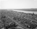
| Description: | Bird's-eye view of Fountain City looking south, with high bluff on the left, and the Mississippi River on the right. Fountain City, about 4 blocks wide, ne... |
| Date: | 1925 |
|---|---|
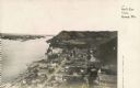
| Description: | Elevated view of Genoa. Caption reads: "Bird's Eye View, Genoa, Wis." The St. Charles Borromeo Catholic Church is in the right foreground. Railroad tracks ... |

| Date: | 1955 |
|---|---|
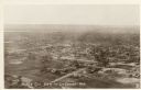
| Description: | Aerial view of La Crosse, with Onalaska in the background. The highway is U.S. Highway 53 and the State Highway 35. |

| Date: | 1953 |
|---|---|
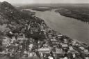
| Description: | Aerial view of La Crosse and the Mississippi River. In the foreground is the new bridge as of 1953. |
| Date: | |
|---|---|
| Description: | Aerial view of La Crosse, with the Mississippi River in the distance. |

| Date: | 1804 |
|---|---|
| Description: | A map of Lewis and Clark's Track across the western portion of North America from the Mississippi River to the Pacific Ocean by order of the Executive of t... |
| Date: | 1960 |
|---|---|
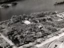
| Description: | Aerial view of Villa Louis on the Mississippi River, and adjacent buildings. |

| Date: | 1673 |
|---|---|
| Description: | Facsimile of the autograph map of the Mississippi or Conception River drawn by Father Marquette at the time of his voyage. From the original preserved at S... |

| Date: | 1930 |
|---|---|
| Description: | Aerial view looking east at Mt. Trempealeau from Brady's Bluff in Perrot State Park. The Mississippi River is visible along the bluffs at upper left, and t... |
If you didn't find the material you searched for, our Library Reference Staff can help.
Call our reference desk at 608-264-6535 or email us at: