Filter: Categories of Wisconsin Historical Images
Filter: Subject of Mississippi River
Filter: Subject of intellectual life
Filter: Subject of transportation
Filter: Categories of Wisconsin Historical Images
Filter: Subject of Mississippi River
Filter: Subject of intellectual life
Filter: Subject of transportation
| Date: | 1921 |
|---|---|
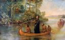
| Description: | Painted scene of an Indian guide paddling, Jacques Marquette, a Jesuit missionary standing, and Louis Joliet, a fur trader paddling in a canoe exploring th... |

| Date: | 1870 |
|---|---|
| Description: | During the War of 1812, the only battle fought in Wisconsin was in Prairie du Chien, in 1814. Made fifty-six years later, this birds eye drawing depicts th... |

| Date: | 1867 |
|---|---|
| Description: | Bird's-eye map of La Crosse with nine insets of residences, schools, and the Court House and Jail. |

| Date: | 1873 |
|---|---|
| Description: | Bird's-eye map of La Crosse from the Mississippi River. |

| Date: | 1880 |
|---|---|
| Description: | Bird's-eye map over the Mississippi River of Fountain City. Paddle steamers and steamboats are on the river, and bluffs are in the background. |

| Date: | 1884 |
|---|---|
| Description: | Bird's-eye view drawing of the grounds of Villa Louis, the estate of the fur trading Dousman family. After the death of H. Louis Dousman's mother in 1882, ... |
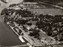
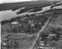
| Date: | 1910 |
|---|---|
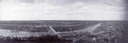
| Description: | Aerial view of town, with a river and the horizon in the distance. |

| Date: | 1925 |
|---|---|
| Description: | Bird's-eye view of Fountain City looking south, with high bluff on the left, and the Mississippi River on the right. Fountain City, about 4 blocks wide, ne... |
| Date: | 1925 |
|---|---|
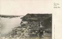
| Description: | Elevated view of Genoa. Caption reads: "Bird's Eye View, Genoa, Wis." The St. Charles Borromeo Catholic Church is in the right foreground. Railroad tracks ... |

| Date: | 1955 |
|---|---|
| Description: | Aerial view of river and town from a military airplane. |

| Date: | 1955 |
|---|---|
| Description: | Aerial view of La Crosse, with Onalaska in the background. The highway is U.S. Highway 53 and the State Highway 35. |

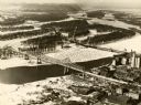
| Date: | 1953 |
|---|---|
| Description: | Aerial view of La Crosse and the Mississippi River. In the foreground is the new bridge as of 1953. |
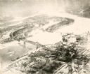
| Date: | 1935 |
|---|---|
| Description: | An aerial view of La Crosse and the Mississippi River with the bridge drawn in to show what the finished product would look like. |

| Date: | 1940 |
|---|---|
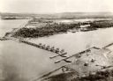
| Description: | Aerial view of the bridge spanning the Mississippi River in La Crosse. |
| Date: | 1940 |
|---|---|
| Description: | The bridge spanning the Mississippi River in La Crosse. |
| Date: | 1958 |
|---|---|
| Description: | Aerial view of town. A bridge over the Mississippi River is in the foreground. |
| Date: | 1896 |
|---|---|
| Description: | Guest ticket for the Republican National Convention held in St. Louis. The ticket shows the celebrated Eads Bridge across the Mississippi, and the log cab... |
| Date: | 03 28 1949 |
|---|---|
| Description: | Aerial view of Prairie du Chien showing the Mississippi River in the background. |
If you didn't find the material you searched for, our Library Reference Staff can help.
Call our reference desk at 608-264-6535 or email us at: