 Filter: Categories of Wisconsin Historical Images
Filter: Subject of Mississippi River
Filter: Year of 1900-1999
Filter: Categories of Wisconsin Historical Images
Filter: Subject of Mississippi River
Filter: Year of 1900-1999
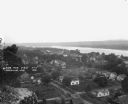
| Date: | 1921 |
|---|---|
| Description: | View from bluff of Cassville with the Mississippi River in the background. |
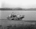
| Date: | 1921 |
|---|---|
| Description: | View from shoreline looking down at three men posing on a paddle steamer ferry boat carrying an automobile. The boat has the words "Cassville" and "Dewey" ... |

| Date: | 1928 |
|---|---|
| Description: | This map shows geological formations throughout Wisconsin. Lakes and rivers are labeled, including The Mississippi River, Lake Superior, and Lake Michigan.... |
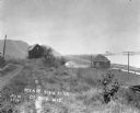
| Date: | 1914 |
|---|---|
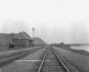
| Description: | View down path along rough road towards a building labeled "No. 4". The De Soto Depot, railroad tracks, a boxcar, and the Mississippi River are below on th... |
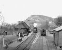
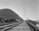
| Date: | 1912 |
|---|---|
| Description: | Elevated view of the De Soto depot. A locomotive, blowing steam, is approaching the platform, where a small group of people waits to board. A boxcar on the... |
| Date: | 1925 |
|---|---|
| Description: | View down double set of railroad tracks with the De Soto depot on the left and the Mississippi River on the right. A car is parked at the depot, and bluffs... |

| Date: | 1930 |
|---|---|
| Description: | Pen and ink map on paper of Wisconsin and northern Illinois showing stagecoach routes (marked in red) that traveled between Lake Michigan and the Mississip... |

| Date: | 1919 |
|---|---|
| Description: | This map depicts the route of the 1842 overland trip by wagon made by the Reverend Alfred Brunson and some copper miners from Prairie du Chien to the mouth... |

| Date: | 1935 |
|---|---|
| Description: | This map shows Wisconsin’s pinery region. Lake Superior, Lake Michigan, Lake Winnebago, Green Bay, the Wisconsin River, and the Mississippi River are label... |

| Date: | 1920 |
|---|---|
| Description: | Shows 10 land and water trails along rivers and other bodies of water in northern Wisconsin and the Upper Peninsula of Michigan; each trail numbered and de... |

| Date: | 1942 |
|---|---|
| Description: | This map shows the Wisconsin and Fox River routes in green, and the Milwaukee and Rock River Canal routes in red. Prairie du Chien, Fort Winnebago, Grand C... |

| Date: | 1928 |
|---|---|
| Description: | Map of portions of Wisconsin and Minnesota between Lake Superior and Mississippi River, showing railroads and military road. |

| Date: | 1900 |
|---|---|
| Description: | A map of Wisconsin, eastern Minnesota and Iowa, northern Iowa, and Michigan’s Upper Peninsula, showing railway lines, with those marked with heavy red line... |

| Date: | 1900 |
|---|---|
| Description: | This map, which shows the state of Wisconsin in 1895, was published as Rand, McNally & Co.'s New business atlas map of Wisconsin. Railroads, counties, citi... |
| Date: | 1912 |
|---|---|
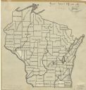
| Description: | An ink and pencil on paper map of Wisconsin that shows contemporary county divisions in the state. The map depicts the locations of some of the rivers that... |
| Date: | 1907 |
|---|---|
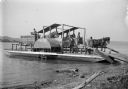
| Description: | Horse-powered Mississippi River Ferry. This ferry was operated between Turkey river, Iowa and Cassville, Wisconsin by Alfred Dietrich. |

| Date: | 1929 |
|---|---|
| Description: | View down high bridge of two passenger cars passing one another while crossing over the Mississippi River. |
| Date: | 1922 |
|---|---|
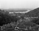
| Description: | View from the hilltop at the Genoa cemetery looking down towards the village, the Mississippi River and the Minnesota border. |
| Date: | 1909 |
|---|---|
| Description: | View along a brick platform towards the Glen Haven depot, where two men stand against the building. Behind the depot is a building with a sign for the "Me... |

| Date: | 1916 |
|---|---|
| Description: | A pen on paper, hand-drawn map that shows the railroads, rivers, county outlines, and cities and villages in Wisconsin, northern Illinois, and the western ... |
If you didn't find the material you searched for, our Library Reference Staff can help.
Call our reference desk at 608-264-6535 or email us at: