 Filter: Categories of Wisconsin Historical Images
Filter: Subject of Mounds
Filter: Subject of cities and towns
Filter: Categories of Wisconsin Historical Images
Filter: Subject of Mounds
Filter: Subject of cities and towns

| Date: | 1913 |
|---|---|
| Description: | Ink and watercolor on tracing cloth. Shows parts of Green Lake, Princeton, and Brooklyn townships, Indian mound groups, Green Lake, and other significant b... |

| Date: | |
|---|---|
| Description: | Map showing Indian mounds in Milwaukee's Second Ward from a sketch made by Increase Lapham in 1836. Streets shown on the map include 6th Street, 5th Street... |

| Date: | 1800 |
|---|---|
| Description: | This map on two sheets shows a group of ancient mounds near the southeast corner of the city of Beloit and a group of ancient mounds north of Rockton Stati... |

| Date: | 1873 |
|---|---|
| Description: | A map of the township of Primrose from the "Atlas of Dane County." |

| Date: | 1903 |
|---|---|
| Description: | This maps shows what may be Ho Chunk Native American burial mounds. Also noted on the map is the Fox River, the Doty homestead, stockade embankment, the We... |

| Date: | 1924 |
|---|---|
| Description: | This pictorial map focuses on the Madison Isthmus, Lake Mendota, Lake Monona, Lake Wingra, and shows points of historical interest, buildings, parks, and I... |

| Date: | |
|---|---|
| Description: | This map is pen-and-ink on tracing paper with a mounted legend and shows the Kickapoo River, Indian mounds, the 1st Fort Crawford, an Indian Agency, the si... |

| Date: | 10 1911 |
|---|---|
| Description: | This map shows lot numbers, building lines, roads, trees, and Indian mounds. Relief is shown by contours. Includes manuscript annotations marking parks. |

| Date: | 01 1969 |
|---|---|
| Description: | A map of Oneida county, which includes a small drawing of a hodag. |

| Date: | 1919 |
|---|---|
| Description: | Narrow red lines show principal secondary highways. Green circles shows points of historical interest. Green triangles show Indian mounds and Indian villag... |

| Date: | 1861 |
|---|---|
| Description: | This map shows townships and sections, landownership, roads, railroads, rural residences, schools, churches, and topography. Also included are inset maps o... |

| Date: | 1864 |
|---|---|
| Description: | This map shows locations of quarries, sink holes, creeks, springs, rivers, houses, forts, and roads. Annotations in pencil read: "Is the top of the mound l... |
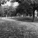
| Date: | 10 2013 |
|---|---|
| Description: | A grove of trees growing behind a line of gravestones at Forest Hill Cemetery, and what may be an effigy mound. Fallen leaves are on the grass. |

| Date: | 1900 |
|---|---|
| Description: | This photocopy map shows marshes, woods, buildings, and selected features including islands, mounds, old Fort Crawford, and "new site for a fort in questio... |

| Date: | 01 12 2016 |
|---|---|
| Description: | Protesters gathering at the Save the Mounds demonstration around the Capitol Square against Assembly Bill 620. A protest sign is attached to the statue "Fo... |

| Date: | 01 12 2016 |
|---|---|
| Description: | Save the Mounds demonstration around the Capitol Square against Assembly Bill 620. In the foreground on the right is a feather headdress worn by a tribal m... |

| Date: | 01 12 2016 |
|---|---|
| Description: | People gathered at the Save the Mounds demonstration around the Capitol Square against Assembly Bill 620. In the foreground is a tribal member wearing a fe... |

| Date: | 01 12 2016 |
|---|---|
| Description: | Save the Mounds demonstration at the Capitol Square against Assembly Bill 620. Flag and Standard bearers are lined up behind the speakers. In the backgroun... |

| Date: | 01 12 2016 |
|---|---|
| Description: | Save the Mounds demonstration around the Capitol Square against Assembly Bill 620. Elevated view of the protesters on the Capitol grounds looking towards S... |

| Date: | 01 12 2016 |
|---|---|
| Description: | Save the Mounds demonstration around the Capitol Square against Assembly Bill 620. View looking up at the Flag and Standard bearers lined up behind the spe... |
If you didn't find the material you searched for, our Library Reference Staff can help.
Call our reference desk at 608-264-6535 or email us at: