 Filter: Categories of Wisconsin Historical Images
Filter: Subject of Mounds
Filter: Subject of human settlements
Filter: Year of 1900-1999
Filter: County of Dane
Filter: Categories of Wisconsin Historical Images
Filter: Subject of Mounds
Filter: Subject of human settlements
Filter: Year of 1900-1999
Filter: County of Dane
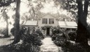
| Date: | 07 1933 |
|---|---|
| Description: | Front view of Man Mound House, with trees and a walkway which leads to the front door. The walkway appears to be on a mound. |
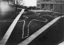
| Date: | 1910 |
|---|---|
| Description: | Elevated view of a double-tailed turtle effigy mound on Observatory Hill on the University of Wisconsin-Madison campus. |
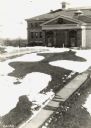
| Date: | 09 28 1942 |
|---|---|
| Description: | Elevated view of turtle mound on the University of Wisconsin-Madison campus. |

| Date: | 1935 |
|---|---|
| Description: | Members of the Wisconsin Outing Club watch the excavation of a burial mound at the Outlet group in 1935. |

| Date: | 1915 |
|---|---|
| Description: | A row of conical burial mounds adjoins the Park and Pleasure Drive on the north shore of Lake Wingra (now Edgewood Drive, at the south edge of Edgewood Col... |
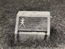
| Date: | 1930 |
|---|---|
| Description: | Turtle Effigy mound marker on the University of Wisconsin-Madison campus. There is a metal plaque on a small formed block. An image of the mound is on the ... |

| Date: | 1927 |
|---|---|
| Description: | Blueprint-style map of Frost Woods on the shore of Lake Monona. The map indicates the locations of Indian mounds, an Indian camp, and various plants. There... |

| Date: | 04 12 1912 |
|---|---|
| Description: | Diagram of a bird effigy mound found in Frost's Woods, Blooming Grove Township. |

| Date: | 1974 |
|---|---|
| Description: | This 1974 map is a reproduction of the original survey maps of the Four Lakes region of Dane County, Wisconsin. It shows sections, lakes, rivers, wetlands,... |

| Date: | 1924 |
|---|---|
| Description: | This pictorial map focuses on the Madison Isthmus, Lake Mendota, Lake Monona, Lake Wingra, and shows points of historical interest, buildings, parks, and I... |

| Date: | 10 1911 |
|---|---|
| Description: | This map shows lot numbers, building lines, roads, trees, and Indian mounds. Relief is shown by contours. Includes manuscript annotations marking parks. |

| Date: | 05 23 1958 |
|---|---|
| Description: | Construction begins on Spring Harbor School, 1110 Spring Harbor Drive just north of University Avenue. The building was designed by Kaeser and McLeod Archi... |
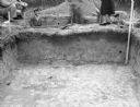
| Date: | 11 01 1947 |
|---|---|
| Description: | View across an excavation toward men and women standing above and behind it. Men are in another excavated hole behind it. Caption reads: "Excavation in cir... |
If you didn't find the material you searched for, our Library Reference Staff can help.
Call our reference desk at 608-264-6535 or email us at: