Filter: Categories of Wisconsin Historical Images
Filter: Subject of Mounds
Filter: Subject of human settlements
Filter: Year of 1900-1999
Filter: Categories of Wisconsin Historical Images
Filter: Subject of Mounds
Filter: Subject of human settlements
Filter: Year of 1900-1999
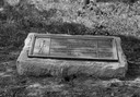
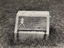
| Date: | 1920 |
|---|---|
| Description: | Historic site marker to commemorate Man Mound and to mark Man Mound Park. The inscription reads "Man Mound Park. Mound located and platted by W.H. Canfield... |
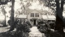
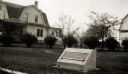
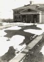
| Date: | 07 1933 |
|---|---|
| Description: | Front view of Man Mound House, with trees and a walkway which leads to the front door. The walkway appears to be on a mound. |
| Date: | 1930 |
|---|---|
| Description: | View of the panther itaglio effigy mound marker, located on Highway 106 West. The text on the marker reads: "Panther Intaglio Effigy; Panther Type, Length ... |

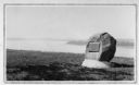
| Date: | 1936 |
|---|---|
| Description: | View of the panther intaglio effigy mound marker, located on Highway 106 West. The text on the marker reads: "Indian Intaglio Effigy; Panther Type, Length ... |
| Date: | 1930 |
|---|---|
| Description: | View of an Indian mounds marker on the St. Croix River. |
| Date: | 1910 |
|---|---|
| Description: | Elevated view of a double-tailed turtle effigy mound on Observatory Hill on the University of Wisconsin-Madison campus. |
| Date: | 1924 |
|---|---|
| Description: | A marker showing an Indian Mound in La Crosse. |
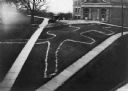
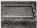
| Date: | 09 28 1942 |
|---|---|
| Description: | Elevated view of turtle mound on the University of Wisconsin-Madison campus. |
| Date: | 1963 |
|---|---|
| Description: | The marker notes Man Mound Park by the Wisconsin Archeological Society, Sauk County Historical Society and the Landmark Committee, W.F.W.C. |
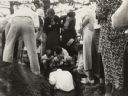
| Date: | 1935 |
|---|---|
| Description: | Members of the Wisconsin Outing Club watch the excavation of a burial mound at the Outlet group in 1935. |

| Date: | 1915 |
|---|---|
| Description: | A row of conical burial mounds adjoins the Park and Pleasure Drive on the north shore of Lake Wingra (now Edgewood Drive, at the south edge of Edgewood Col... |
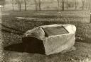
| Date: | 1930 |
|---|---|
| Description: | Turtle Effigy mound marker on the University of Wisconsin-Madison campus. There is a metal plaque on a small formed block. An image of the mound is on the ... |

| Date: | 1927 |
|---|---|
| Description: | Blueprint-style map of Frost Woods on the shore of Lake Monona. The map indicates the locations of Indian mounds, an Indian camp, and various plants. There... |

| Date: | 04 12 1912 |
|---|---|
| Description: | Diagram of a bird effigy mound found in Frost's Woods, Blooming Grove Township. |

| Date: | 1931 |
|---|---|
| Description: | This map of south central Wisconsin shows lakes, rivers, cities, villages, highways and roads, railroads, Indian mounds, and points of scenic and historic ... |

| Date: | 1920 |
|---|---|
| Description: | This 1920 map actually depicts present-day Wyalusing State Park at the confluence of the Mississippi and Wisconsin rivers in the Town of Wyalusing, Grant C... |

| Date: | 1915 |
|---|---|
| Description: | This 1915 map covers portions of Barron, Chippewa, and Rusk counties in Wisconsin. Shown are the township and range grid, sections, cities and villages, ra... |

| Date: | 1974 |
|---|---|
| Description: | This 1974 map is a reproduction of the original survey maps of the Four Lakes region of Dane County, Wisconsin. It shows sections, lakes, rivers, wetlands,... |
If you didn't find the material you searched for, our Library Reference Staff can help.
Call our reference desk at 608-264-6535 or email us at: