 Filter: Categories of Wisconsin Historical Images
Filter: Subject of Mounds
Filter: Subject of indians of north america
Filter: Categories of Wisconsin Historical Images
Filter: Subject of Mounds
Filter: Subject of indians of north america

| Date: | 1850 |
|---|---|
| Description: | Map showing Indian mounds and graves as well as ground cover types at Township 8, Range 22. There is an inset diagram of an effigy mound labeled "The Cross... |

| Date: | |
|---|---|
| Description: | Map showing Indian mounds in Milwaukee's Second Ward from a sketch made by Increase Lapham in 1836. Streets shown on the map include 6th Street, 5th Street... |

| Date: | |
|---|---|
| Description: | Photographic postcard view of three views from Aztalan State Park; Indian Mound at sunset, pottery, and a fence. |

| Date: | 1903 |
|---|---|
| Description: | This maps shows what may be Ho Chunk Native American burial mounds. Also noted on the map is the Fox River, the Doty homestead, stockade embankment, the We... |

| Date: | 1924 |
|---|---|
| Description: | This pictorial map focuses on the Madison Isthmus, Lake Mendota, Lake Monona, Lake Wingra, and shows points of historical interest, buildings, parks, and I... |

| Date: | 1933 |
|---|---|
| Description: | Blue print and blue line print maps that show local streets, Nakoma Country Club, part of Lake Forest, and part of Lake Wingra. A legend is included that s... |

| Date: | 1945 |
|---|---|
| Description: | This maps shows roads, railroads, parks, recreational areas, Lake Wingra, Lake Monona, and part of Lake Mendota. The map includes pictorial images that dep... |

| Date: | |
|---|---|
| Description: | This map is pen-and-ink on tracing paper with a mounted legend and shows the Kickapoo River, Indian mounds, the 1st Fort Crawford, an Indian Agency, the si... |

| Date: | |
|---|---|
| Description: | View looking uphill towards three platform mounds. The numbers 1, 2, and 3 are written on the photograph in ink. Part of the way up the hill are a small sh... |
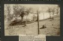
| Date: | 1905 |
|---|---|
| Description: | Two of a series of three large platform mounds on the top of a high hill, overlooking the Mississippi and Black River valleys. Two young children are seate... |
| Date: | 1905 |
|---|---|
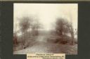
| Description: | View across top of platform mound on the crest of a high hill. Trees are on the left and right. In the background below is the Mississippi River. |

| Date: | 10 1911 |
|---|---|
| Description: | This map shows lot numbers, building lines, roads, trees, and Indian mounds. Relief is shown by contours. Includes manuscript annotations marking parks. |
| Date: | 05 31 1935 |
|---|---|
| Description: | Students digging into a bird effigy mound on the University of Wisconsin campus on May 31 through June 1, 1935. |

| Date: | 07 30 1910 |
|---|---|
| Description: | Group of people standing on an eagle effigy mound on State Hospital grounds. |

| Date: | |
|---|---|
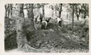
| Description: | A small group of men, some of them carrying bags, walk in a field among effigy mounds. |

| Date: | 06 1911 |
|---|---|
| Description: | A field party of members of the Wisconsin Archaeological Society visit an effigy mound at Big Bend. The men are dressed in suits and hats. |
| Date: | 10 16 1910 |
|---|---|
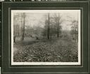
| Description: | View of a linear Indian mound at Big Bend. Two men stand in the background on the left and right among the trees. |

| Date: | 06 30 1910 |
|---|---|
| Description: | People gathered for a ceremony at the unveiling of a marker at an eagle effigy mound on the State Hospital Grounds. |

| Date: | 1925 |
|---|---|
| Description: | This map shows trails, mounds, villages, corn fields, and contemporary civil townships; some villages and features include both Indian and English place na... |
If you didn't find the material you searched for, our Library Reference Staff can help.
Call our reference desk at 608-264-6535 or email us at:
